graphic-art, print, etching, engraving
#
graphic-art
#
baroque
# print
#
etching
#
landscape
#
etching
#
engraving
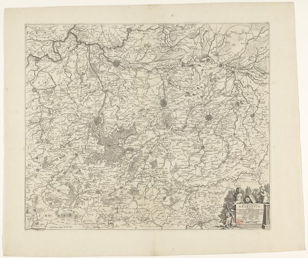
Dimensions: height 475 mm, width 580 mm
Copyright: Rijks Museum: Open Domain
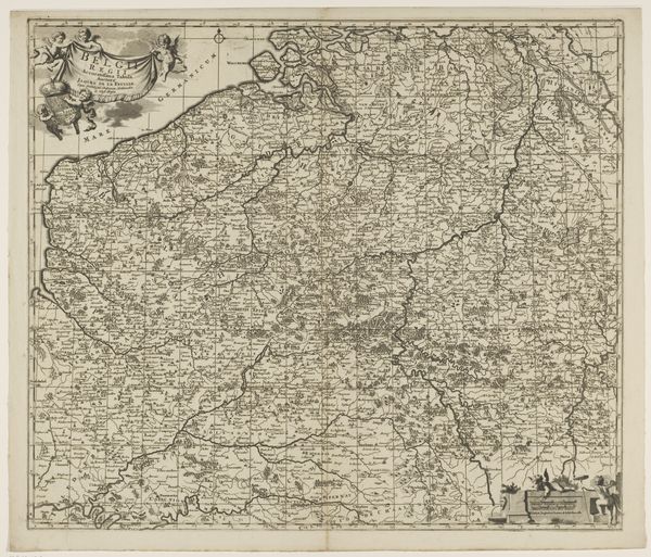
Curator: Oh, this feels like a riddle etched in ink! So many tiny details vying for attention... kind of overwhelming at first glance, no? Editor: This is an engraving titled "Kaart van het graafschap Namen" or "Map of the County of Namur". The Rijksmuseum dates this graphic art piece anonymously between 1645 and 1706, noting it was created using etching and engraving techniques. Curator: Ah, a map! Suddenly, the organized chaos makes sense. But what strikes me is how... lush it appears. All those stippled textures, like a topographical poem! Did they really see the world this way back then, all undulating hills and clustered secrets? Editor: Maps of this era are less about exact representation, and more about power, ownership, and what a place *meant* to those commissioning them. Look at the ornate cartouche, the lion rampant, holding the heraldic shield. A statement! Visual rhetoric disguised as geography. Curator: Yes! It's not just about "here's where things ARE," but "here's what we VALUE." It's like... branding a landscape, stamping a visual claim of dominance. What do you make of the way they rendered the river? Editor: That serpentine line clearly dominates. Waterways, especially back then, were arteries of life and commerce – and prime strategic real estate, of course. See how the cities cluster along its banks? Curator: Absolutely, like pearls on a string. And those tiny, almost obsessive details! Imagine the dedication, the sheer eye strain involved in etching all that. Is that a... a tiny forest I spot there? Editor: Indeed. Baroque landscapes like this loved that dense layering –horror vacui, the fear of empty space made artful! Every grove and hamlet serves a purpose. Perhaps to emphasize the land’s cultivated bounty or its defensible features? Remember maps often doubled as propaganda. Curator: It does feel like I'm deciphering a hidden language. So what lingers with you after considering this detailed vista, now? Editor: The realization that even seemingly objective records—like maps—are profoundly subjective cultural artifacts, revealing as much about the mapmakers as the territory they depict.
Comments
No comments
Be the first to comment and join the conversation on the ultimate creative platform.
More like this