graphic-art, print, engraving
graphic-art
aged paper
toned paper
light pencil work
baroque
old engraving style
hand drawn type
landscape
personal sketchbook
pen-ink sketch
pen work
sketchbook drawing
sketchbook art
engraving
Dimensions: height 505 mm, width 595 mm
Copyright: Rijks Museum: Open Domain
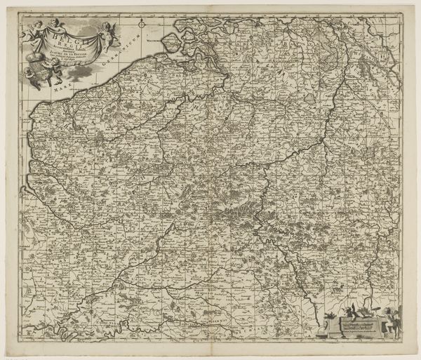
Curator: Here we have an early 18th-century engraving from an anonymous artist, titled "Kaart van het graafschap Henegouwen," which translates to "Map of the County of Hainaut." It's part of the Rijksmuseum's collection. Editor: It immediately strikes me as an object of power and control. There's such precision in mapping territory, it feels like an assertion of dominance, even with its aged and delicate lines. Curator: Maps, you see, were potent symbols then. More than geographical guides, they were visual embodiments of order and authority. Take note of the allegorical figures adorning the margins. Notice how they are rendered with specific detail in the baroque style, giving us a glimpse into the cultural values they reflected? Editor: The Baroque elements do soften the potentially harsh implications of territorial surveying, don’t they? It's like the cartographer wanted to suggest this wasn't just about lines on a page but about people, prosperity, perhaps even divine favor. I think its connection with modern geopolitical theory and ongoing conflicts should be acknowledged. How does what is included or excluded, emphasized, or de-emphasized play into claims and disputes about this very territory today? Curator: True, the map depicts Hainaut, now divided between Belgium and France. Consider how the act of mapping defines—and perhaps even confines—identity within these borders. Boundaries not only divide spaces, but people, histories, and cultures as well. The way villages, forests, and rivers are detailed… they all contribute to a particular vision. The symbols tell us which cities or territories are aligned in their fealty to particular leaders. The symbolic representation really carries cultural weight. Editor: And who decides what those symbols *mean*? Power dynamics are not simply portrayed, but perpetuated through such depictions. What perspectives are silenced or minimized here, I wonder? And how does its very existence today—displayed in the museum—serve to normalize these historical divisions or prompt us to critically question them? This conversation certainly reinforces how a map, on its surface objective, is undeniably infused with politics and identity. Curator: It seems we’ve charted a course into the deeper meanings held within this seemingly simple map. Understanding the cultural language and impact these historical engravings held can shed much light on both our present, and how visual culture shapes history, wouldn't you say? Editor: Absolutely, examining maps critically pushes us to reconsider the power structures embedded in even the most unassuming historical artifacts.
Comments
No comments
Be the first to comment and join the conversation on the ultimate creative platform.