print, engraving
#
dutch-golden-age
# print
#
landscape
#
engraving
Dimensions: height 400 mm, width 474 mm
Copyright: Rijks Museum: Open Domain
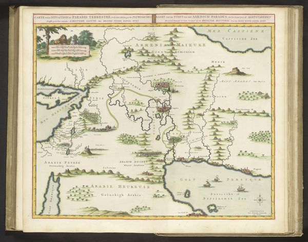
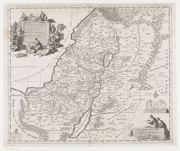
Curator: This detailed map is entitled "Kaart van het Heilige Land," created around 1700 by Dirk Janszoon van Santen, executed as an engraving. It depicts the Holy Land, including depictions of people on the top-left and bottom-right corners of the image. Editor: My first thought is the incredible detail. The intricacy in illustrating the landscape, and the scenes integrated, offer not just geographical information, but almost a story within a map. It feels very much of its time, almost performative in a way, because they could've used very basic means, but instead they dedicated this amount of artistic quality. Curator: Absolutely. Considering its context, we have to remember maps weren’t solely for navigation. During the Dutch Golden Age, cartography had an incredible public role, especially through disseminating and confirming narratives of religious history. This piece definitely situates itself in this role. Editor: You’re right. The title itself signals that. And the inclusion of people suggests certain ideological frameworks being supported here, and the style feels both documentary and glorifying. It makes me think about who had access to it, and what kind of social circles it was intended for. Curator: Definitely upper-class circles that engaged with artistic expressions as a means of intellectual and social exchange, those invested in biblical scholarship. The Dutch Golden Age also saw growing discussions around interpreting sacred texts. Therefore, a map like this becomes part of the public arena for social and religious discourse, making knowledge of those territories accessible while maintaining certain perspectives. Editor: Exactly. These kinds of illustrations weren't simply mirroring geographical information; it actively contributed to constructing a European understanding of those territories, carrying with it assumptions about cultural significance. Considering that this area is constantly in a state of geopolitical tension, I find it revealing to go back to artistic depictions of past eras to discuss these issues further. Curator: It is vital for a critical dialogue of visual materials, one that examines how the sociopolitical landscape influences the reception and reproduction of artworks such as this one, even to this day. Editor: Precisely, analyzing imagery can challenge viewers' presumptions of neutrality within archival illustrations and explore the cultural forces influencing historical documents.
Comments
No comments
Be the first to comment and join the conversation on the ultimate creative platform.
More like this