drawing, print, paper, ink, engraving
#
drawing
#
baroque
# print
#
paper
#
ink
#
geometric
#
cityscape
#
decorative-art
#
engraving
Dimensions: height 182 mm, width 266 mm
Copyright: Rijks Museum: Open Domain
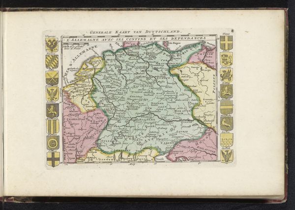
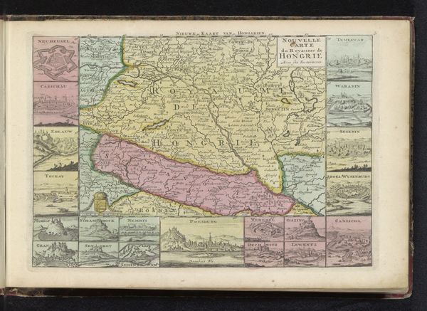
Editor: This is an intriguing engraved map titled "Kaart van Beieren," or "Map of Bavaria," created anonymously sometime between 1700 and 1735. It’s beautifully detailed with cityscapes bordering the main map. What stands out to you when you look at this, what symbols or historical context do you think are important to consider? Curator: The geometric forms and intricate details, while seemingly objective, reveal much about power, perception, and place. Notice the prominence of fortified cities, depicted as star-shaped citadels. What do these repeated fortifications signify to you? Editor: I guess it’s about control. Claiming territory. The little stars are defensive walls, showing the strength of the city. Curator: Exactly. Fortifications become emblems, projecting power and order. The map isn't merely a representation of geographical space. It’s a statement. A carefully constructed symbol of a specific political and cultural order. Note the title cartouche – how does the ornamentation shape our understanding? Editor: It makes the information seem more important and formal, doesn’t it? I hadn't thought of it that way, but the frame itself communicates prestige. It feels like I’m looking at more than just directions. It speaks to claiming authority over Bavaria. Curator: Precisely. So, seeing those repeated symbolic elements, what continuous narratives or cultural values might this map reveal? Editor: I see the map as this statement, like you said, staking a claim about Bavarian identity during a time of shifting European powers. Thanks, I won't look at maps the same way. Curator: Maps, like any visual representation, tell curated stories. Recognizing those symbolic choices invites us to question whose stories are being told and how.
Comments
No comments
Be the first to comment and join the conversation on the ultimate creative platform.
More like this