graphic-art, print, engraving
#
graphic-art
#
baroque
# print
#
orientalism
#
islamic-art
#
history-painting
#
engraving
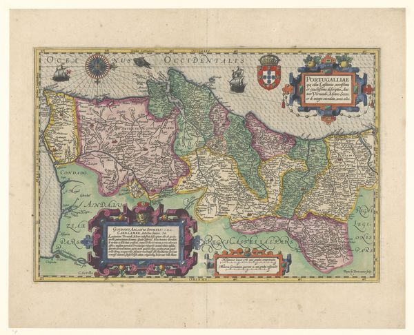
Dimensions: height 283 mm, width 370 mm
Copyright: Rijks Museum: Open Domain
Editor: This is an engraving called "Kaart van Perzië," or "Map of Persia," created by Matthäus Merian after 1634. It's fascinating to see Persia rendered in this style, and the figures in the corner make me wonder who the intended audience was. What stands out to you about this print? Curator: From a materialist perspective, consider the laborious process of engraving in the 17th century. Each line etched, each dot carefully placed on the metal plate, speaks volumes about the relationship between labor and the production of knowledge. This wasn't just about geographical accuracy; it was about European control of knowledge production related to Persia. How would such control be applied back then, do you think? Editor: Presumably, such knowledge would have geopolitical applications for trade and empire-building. Did the creation and circulation of these prints challenge the established artistic hierarchies? Curator: Absolutely. Think about the division of labor inherent in printmaking – the artist who designs, the artisan who engraves, the publisher who distributes. These roles blurred the lines between art and craft, challenging the established hierarchy of the art world at the time. How did the materials themselves, like the paper and ink, contribute to the circulation and consumption of these ideas about Persia? Editor: The relatively inexpensive materials compared to, say, oil paint, allowed for wider dissemination. That democratized the image and broadened the audience. This suggests the print's influence was quite far-reaching, especially if these images helped to shape popular imagination of Persia in Europe. Curator: Precisely! And consider where this map would have been consumed: in the homes of merchants, in the offices of trading companies. The very act of consuming this image solidified certain economic and social relationships between Europe and Persia. We tend to isolate 'high art' from such influences, don’t we? Editor: It’s fascinating how a seemingly straightforward map reveals such complex connections between art, labor, and power. Thank you, this new perspective helped to broaden my understanding! Curator: Indeed. Analyzing art through the lens of materiality truly opens up new avenues for interpretation. I will look for new insights on my end too.
Comments
No comments
Be the first to comment and join the conversation on the ultimate creative platform.
More like this