About this artwork
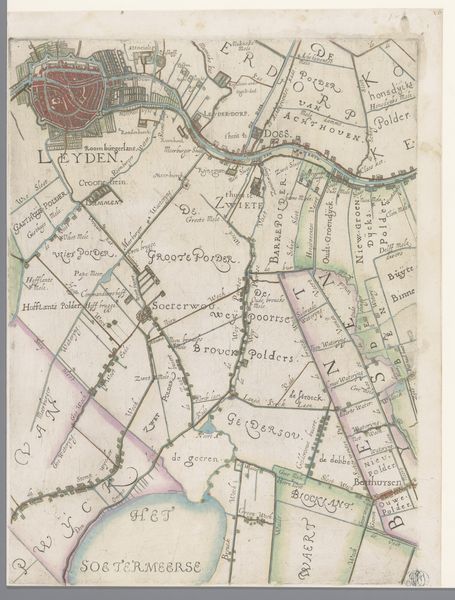
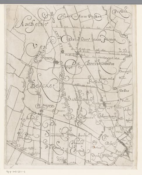
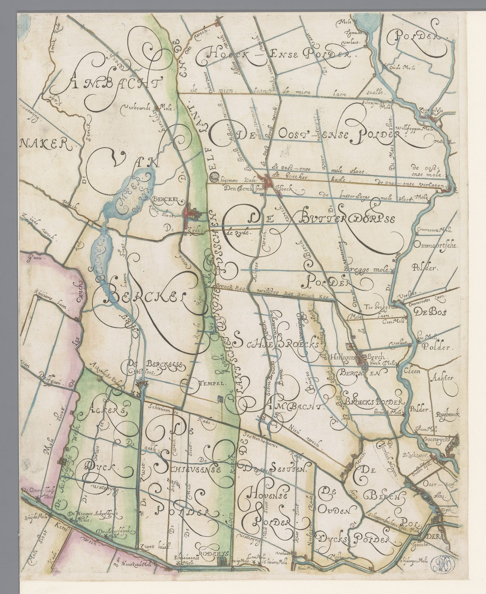
Curator: Look at the fine lines on this drawing, made with ink on paper. This is "Map of the Delfland Water Board, with Berkel en Rodenrijs, Right Middle Section," by Floris Balthasarsz van Berckenrode, likely created sometime between 1611 and 1692. It's held in the Rijksmuseum collection. Editor: It feels almost...claustrophobic. So many names, boundaries, as if the land itself is being pinned down and claimed. A feeling of enforced order. Curator: Precisely. Maps like this were crucial for asserting control. The Delfland Water Board managed the water levels in this region of the Netherlands, vital for agriculture and preventing floods. Editor: So, the act of mapping itself is symbolic, representing humankind's attempts to control nature, right? These polders, these managed waterways, aren't natural. Curator: Exactly. And it also highlights the cultural importance of land ownership and management in Dutch society. The careful delineations of the territories become almost like personal seals. Editor: I’m also intrigued by the areas that *aren't* clearly defined. The blueness around the waterways suggest ambiguity and transitional areas which feels emotionally relevant. Are these open areas or the possibility of what is uncontained? Curator: Perhaps. The blank areas within could signify potential – areas yet to be fully drained and cultivated or common grazing ground. These would have also possessed symbolic weight. Consider the historical struggles surrounding land use and access. The drawing can be interpreted as more than an administrative record. Editor: There's such detail and artistry involved. The line work has an elegant precision, a declaration of dominion in artistic form. Was it commonly displayed as an act of asserting territory or for public consumption, perhaps to remind the citizens of their rights? Curator: It likely served practical administrative purposes primarily. Maps were tools, not simply displays of artistry. This document serves both art and cultural touchstone and speaks volumes about governance of that era. Editor: Knowing all that reshapes my perception of the map. It’s now less about confinement and more about aspiration, the will to build and maintain. Curator: Yes, it is indeed. When one engages with history one gains not only a knowledge but appreciation.
Kaart van het Hoogheemraadschap van Delfland, met Berkel en Rodenrijs, deel midden rechts
1611 - 1692
Floris Balthasarsz van Berckenrode
1562 - 1616Location
RijksmuseumArtwork details
- Medium
- drawing, paper, ink
- Dimensions
- height 381 mm, width 300 mm
- Location
- Rijksmuseum
- Copyright
- Rijks Museum: Open Domain
Tags
drawing
map drawing
dutch-golden-age
landscape
paper
ink
pen work
cityscape
Comments
Be the first to share your thoughts about this work.
About this artwork
Curator: Look at the fine lines on this drawing, made with ink on paper. This is "Map of the Delfland Water Board, with Berkel en Rodenrijs, Right Middle Section," by Floris Balthasarsz van Berckenrode, likely created sometime between 1611 and 1692. It's held in the Rijksmuseum collection. Editor: It feels almost...claustrophobic. So many names, boundaries, as if the land itself is being pinned down and claimed. A feeling of enforced order. Curator: Precisely. Maps like this were crucial for asserting control. The Delfland Water Board managed the water levels in this region of the Netherlands, vital for agriculture and preventing floods. Editor: So, the act of mapping itself is symbolic, representing humankind's attempts to control nature, right? These polders, these managed waterways, aren't natural. Curator: Exactly. And it also highlights the cultural importance of land ownership and management in Dutch society. The careful delineations of the territories become almost like personal seals. Editor: I’m also intrigued by the areas that *aren't* clearly defined. The blueness around the waterways suggest ambiguity and transitional areas which feels emotionally relevant. Are these open areas or the possibility of what is uncontained? Curator: Perhaps. The blank areas within could signify potential – areas yet to be fully drained and cultivated or common grazing ground. These would have also possessed symbolic weight. Consider the historical struggles surrounding land use and access. The drawing can be interpreted as more than an administrative record. Editor: There's such detail and artistry involved. The line work has an elegant precision, a declaration of dominion in artistic form. Was it commonly displayed as an act of asserting territory or for public consumption, perhaps to remind the citizens of their rights? Curator: It likely served practical administrative purposes primarily. Maps were tools, not simply displays of artistry. This document serves both art and cultural touchstone and speaks volumes about governance of that era. Editor: Knowing all that reshapes my perception of the map. It’s now less about confinement and more about aspiration, the will to build and maintain. Curator: Yes, it is indeed. When one engages with history one gains not only a knowledge but appreciation.
Comments
Be the first to share your thoughts about this work.