print, engraving
#
aged paper
#
toned paper
#
light pencil work
# print
#
old engraving style
#
hand drawn type
#
personal sketchbook
#
sketchbook drawing
#
watercolour illustration
#
history-painting
#
northern-renaissance
#
sketchbook art
#
engraving
#
watercolor
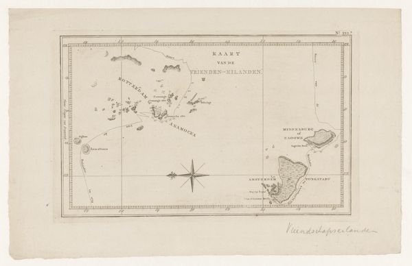
Dimensions: height 317 mm, width 350 mm
Copyright: Rijks Museum: Open Domain
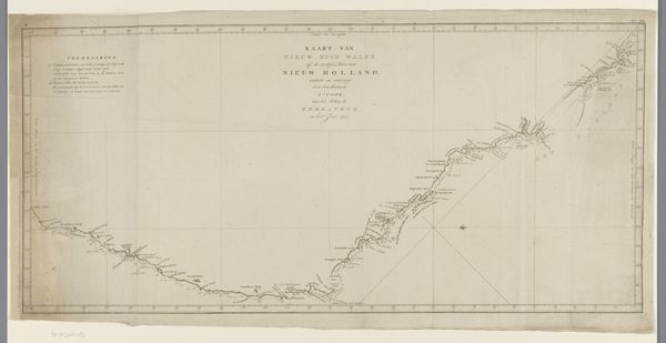
Curator: This engraving from 1798, titled "Kaart van een deel van de kust van Nieuw-Zuid-Wales te Australië," translates to "Map of a part of the coast of New South Wales in Australia." The cartographer credited on the map is Luit J. Cook. Editor: My immediate reaction is the weight of its colonial implications. That coastline, meticulously rendered with delicate lines, represents so much unacknowledged history and violence. There’s a somberness in its monochrome palette. Curator: Exactly. These maps were not simply objective representations; they were instruments of power. Consider the socio-political forces at play in the late 18th century—the era of exploration, colonization, and the assertion of European dominance. Cook's voyages, while presented as scientific endeavors, directly facilitated the claiming of land already inhabited. Editor: And it is a claiming through erasure, right? Look at the visual hierarchy: the bold typeface claiming ‘New South Wales’ overshadows the intricate, almost ghostly details of the coastline. What narratives are intentionally submerged or completely omitted here, and who benefits from their absence? Indigenous perspectives, obviously. Curator: Precisely. This wasn’t a neutral surveying exercise; it was a declaration. The act of mapping itself was an act of possession, imposing a European grid and nomenclature onto an existing reality. And museums today play a critical role in shaping the continuing legacy of these images and objects. Editor: How do we re-contextualize these historical documents then? Acknowledging the silences, tracing the lines of power and control, and centering the voices of those who were literally left off the map. This print embodies the urgent need for art spaces to confront their own complicity in historical oppression. Curator: Indeed. Reflecting on this map reveals not just geographical information, but also a complex interplay of social, political, and ideological forces. Editor: Seeing it this way reminds us how critical and conscious we have to be about the art and the lens we use when studying art history.
Comments
No comments
Be the first to comment and join the conversation on the ultimate creative platform.
More like this