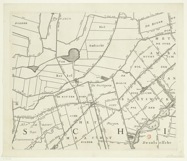
Kaart van het Hoogheemraadschap van Schieland (zesde deel) 1684 - 1718
0:00
0:00
johannesvinckboons
Rijksmuseum
print, etching
#
dutch-golden-age
# print
#
etching
#
landscape
#
etching
#
geometric
#
cityscape
Dimensions: height 500 mm, width 599 mm
Copyright: Rijks Museum: Open Domain
Curator: Before us is a section of the “Kaart van het Hoogheemraadschap van Schieland," or "Map of the Schieland Water Board," dating from between 1684 and 1718, an etching by Johannes Vinckboons. It's a fascinating blend of artistry and practical documentation, now held here at the Rijksmuseum. Editor: It strikes me immediately as incredibly precise, almost obsessively so. The sheer geometric articulation of the land… a grid, carefully laid out, and delicately etched. The balance between the stark geometry and swirling calligraphic elements gives a striking mood of measured orderliness. Curator: Yes, that geometry speaks volumes. It's not just about land; it's about control, about humanity shaping and defining nature. This map was a working document for water management, a constant struggle in the Netherlands. Those grids likely represent polders—reclaimed land, carefully drained and divided. Note the inclusion of three peacocks in the upper heraldic element: they're not simply ornamental, but likely symbolize a certain family and, perhaps, a claim to dominion over this region. Editor: That makes sense. The sharp angles certainly communicate an authority. It’s interesting how the flowing rivers and place names are integrated without disrupting the severe rectilinear organization. It's almost a conversation between human will and natural forms, visualized. Semiotically, it reads like a struggle. Curator: Indeed. Look closely at the place names—"Katwgis Polder Ambacht", for example. These aren't just labels; they're hints to the region's cultural memory and its reliance on a landscape constantly negotiated between water and land, use and threat. These small settlements, clinging to their small sections, carry a powerful cultural and historical burden, don't you think? Editor: Absolutely. And this etching itself is a document in its own right, capturing that historical struggle through very considered lines, shapes and forms. Seeing the territory rendered this way provides a distinct impression on human efforts on environment transformation that, though small in scale, collectively tells an epic. Curator: A worthy summary. For me, the beauty lies in how this practical tool became a lasting testament to human resilience and adaptation. Editor: Agreed. There is something truly special about the relationship between its forms and their representation.
Comments
No comments
Be the first to comment and join the conversation on the ultimate creative platform.
More like this