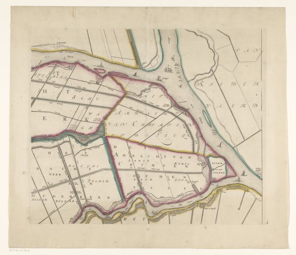
Kaart van het Hoogheemraadschap van Rijnland (dertiende deel) 1647 - 1687
0:00
0:00
cornelisidanckerts
Rijksmuseum
drawing, print, etching, ink
#
drawing
#
dutch-golden-age
# print
#
pen sketch
#
etching
#
old engraving style
#
landscape
#
ink
#
pen-ink sketch
#
pen work
#
cityscape
Dimensions: height 416 mm, width 563 mm
Copyright: Rijks Museum: Open Domain
Editor: So, we’re looking at “Kaart van het Hoogheemraadschap van Rijnland (dertiende deel)” by Cornelis Danckerts I, made between 1647 and 1687. It's a drawing, etching, and print with ink. It looks quite detailed. How would you approach interpreting this map, thinking about it as an artwork? Curator: I'm immediately drawn to the sheer labor evident in this work. Consider the etcher painstakingly rendering this landscape detail by detail. This isn’t just a geographical document; it's a record of human interaction with the land, a manufactured landscape meticulously captured using specific materials and techniques. The act of making, of physically manipulating these materials, imbues the map with cultural and economic significance. Editor: That’s interesting. I hadn’t thought about the labor involved in making a map like this. So you're saying the materials themselves - the ink, the paper, the etching tools - are key to understanding the work's significance? Curator: Precisely. The etching process, the printing, the paper—each contributes to the work's meaning. Also consider who would commission such a map. What does this tell us about power structures and land ownership in the Dutch Golden Age? How would this material object be circulated and consumed? Editor: So, it’s not just about the geography but also the means of production and how the map was used in society at the time? Curator: Exactly. By exploring those production means, like the intaglio printmaking method, and then investigating how those involved—the publisher, artist, and land surveyor—each left their mark on its aesthetic and contextual meaning, you gain real insight into Dutch Golden Age economics, technology, and artistry. Editor: This gives me a whole new way to look at historical maps! Curator: Indeed, seeing them as material products helps us unlock broader historical narratives.
Comments
No comments
Be the first to comment and join the conversation on the ultimate creative platform.
More like this