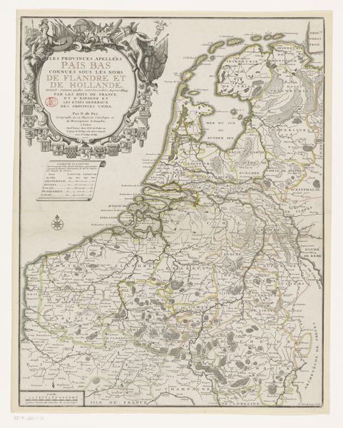
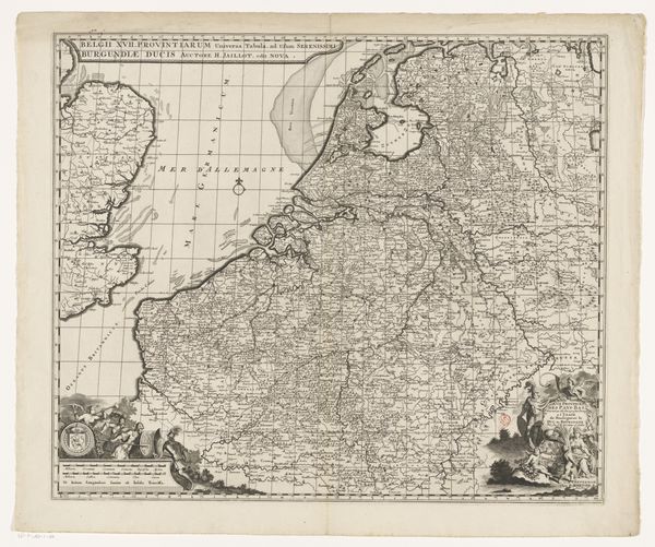
Kaart van de noordelijke provincies van het Koninkrijk der Nederlanden c. 1821
0:00
0:00
anonymous
Rijksmuseum
drawing, graphic-art, print, paper, engraving
#
drawing
#
graphic-art
#
neoclacissism
#
narrative-art
# print
#
landscape
#
paper
#
geometric
#
cityscape
#
engraving
Dimensions: height 475 mm, width 780 mm
Copyright: Rijks Museum: Open Domain
Curator: What strikes me immediately about this print is its remarkable detail. Look at the intricate network of lines; it’s quite an impressive engraving. Editor: Yes, a beautiful demonstration of precision. We're looking at "Kaart van de noordelijke provincies van het Koninkrijk der Nederlanden," a map of the northern provinces of the Kingdom of the Netherlands from around 1821. Curator: Right, it is so interesting to think about this map within the political context of the early 19th century, shortly after the Napoleonic era. Mapping was no longer just about geography but asserting territorial control and national identity. Editor: And visually, note the clarity of the rendering; each town and waterway distinct, the lettering meticulously placed. Curator: Absolutely, the geometric elements point towards a very Neoclassical style, but also raises questions. Who was this map really for? Was it for administrative purposes or something more? Editor: One can imagine the countless hours of surveying and engraving work that went into creating something so comprehensive. The scale must have been crucial to ensuring both accuracy and legibility. Curator: The map also reminds us of the important role these regions played in shaping national policy, trade and the control of natural resources during a time of political restructuring, offering valuable insight into regional power dynamics and their reflection on a unified Netherlands. Editor: Agreed. Looking at the map's design elements, you can see an assertion of rational order. All of the pieces of this composition, while representing tangible places, are presented with exacting and measured balance. It projects, therefore, more than mere representation. Curator: Indeed, maps like these weren't just documents but tools of statecraft. It's a testament to the power of cartography in solidifying the idea of a unified nation and to controlling society via these documents. Editor: A compelling thought. It's fascinating how an ostensibly objective form, like a map, can reflect so many interwoven narratives and ideologies. Curator: Precisely. Next time you look at a map, consider the intricate socio-political stories etched into every line. Editor: And how its formal construction informs and perhaps even reinforces those narratives.
Comments
No comments
Be the first to comment and join the conversation on the ultimate creative platform.
More like this