print, engraving
#
pen drawing
#
dutch-golden-age
#
mechanical pen drawing
# print
#
pen sketch
#
old engraving style
#
geometric
#
pen-ink sketch
#
line
#
cityscape
#
engraving
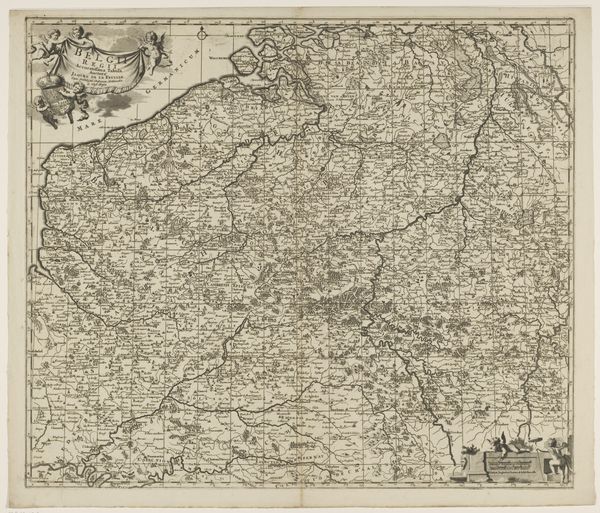
Dimensions: height 482 mm, width 581 mm
Copyright: Rijks Museum: Open Domain
Curator: This is a fascinating engraving, titled "Kaart van de provincie Utrecht," created by Luggert van Anse sometime before 1702. It meticulously maps out the province of Utrecht. Editor: The immediate impression is one of dense detail and precision. Look at the sheer amount of lines packed into a single sheet! It conveys the effort put into understanding and cataloging the landscape. Curator: Precisely. Maps such as this played a key role in solidifying state power. They visualize territorial claims, helping to legitimize governance through the control of spatial knowledge and regulation of natural resources. Who got to decide these lines mattered immensely to marginalized communities. Editor: Agreed, the labor that went into it must have been considerable and, considering it’s an engraving, involving highly skilled work. What's also interesting is how this object, originally functional, transitions into something of artistic value over time. Curator: It's also vital to acknowledge that the artistic choices—what gets emphasized or omitted—are never neutral. Note, for example, the decorative cartouche featuring putti. It connects directly with prevailing power dynamics in that era, intertwining art, labor, class, and access to essential knowledge. Editor: Right. By highlighting the means of production – from surveying techniques to engraving methods - we also have to see how printmaking allowed these concepts of control to be reproduced widely, thus impacting people's understanding of land ownership. Curator: And consider the act of creating this map – what assumptions underpinned Van Anse's perspective, whose vision of Utrecht gets prioritized here? It represents more than just lines on a page. This artifact presents an entire ideological framework shaping perceptions. Editor: Seeing how those perceptions eventually shifted highlights the changing social and environmental realities, as reflected later in artistic practices. It pushes the viewer to ask: "How have the means of visualising a place continued to reinforce certain social norms and political systems throughout art history?" Curator: It challenges us to think deeply not only about maps themselves but rather power structures embedded within every aspect from cartography through our contemporary understanding, acknowledging whose voices remain marginalized when charting any territory throughout our global landscape. Editor: Indeed, through such artifacts, we start exploring links connecting creation to class structures and to broader economic realities affecting its place through society overall; therefore reflecting a tangible connection binding people within labor beyond purely illustrative intentions alone.
Comments
No comments
Be the first to comment and join the conversation on the ultimate creative platform.
More like this