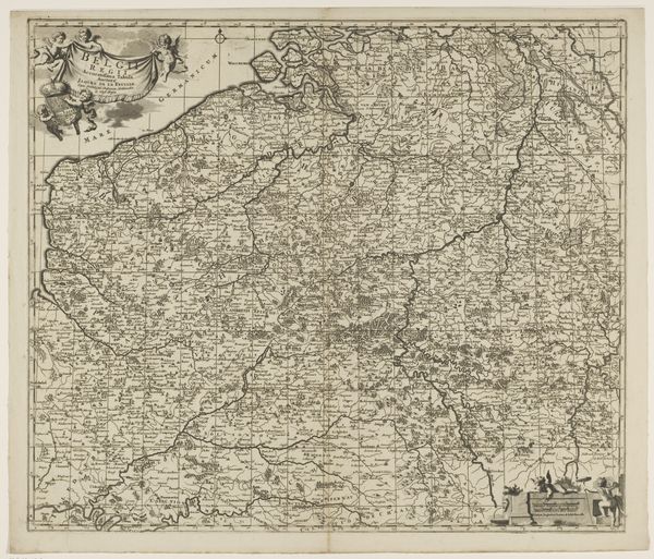
graphic-art, print, engraving
graphic-art
baroque
dutch-golden-age
geometric
line
engraving
Dimensions: height 466 mm, width 565 mm
Copyright: Rijks Museum: Open Domain
Editor: So this is “Kaart van het graafschap Vlaanderen,” a map of the County of Flanders, potentially from between 1666 and 1710 by Abraham Jansz. Deur. It’s a print, an engraving actually. I’m struck by how much detail there is! What's most interesting to you about this piece? Curator: Immediately, I’m drawn to the labor embedded in its creation. Consider the painstaking process of engraving the copperplate, the repetitive, skilled work required to render each tiny detail, from the buildings to the topography. It's not just information; it is a commodity reflecting power. Who commissioned it and how would it be consumed? Editor: That's interesting, the labor. I hadn't thought about it like that. So the purpose was more than geographic? Curator: Absolutely. This wasn’t just about navigation, it was about asserting dominion and control. Maps of this era were tools of empire, defining territories and shaping perceptions of ownership. Consider also the printing process: how many copies were made? Who had access to them? How was this graphic art consumed and disseminated within 17th-century society, shaping social and economic interactions? Editor: I see, the materiality tells the story. The engraving medium speaks to its own historical moment. It wasn’t mass-produced, yet copies existed beyond just one original, influencing trade and political dynamics... Curator: Exactly. Think about the role of De Wit, named in the inscription; clearly a printer and publisher overseeing the production and distribution, not to mention profiting off this labor! Consider the accessibility of the work to different social classes. Could they actually *read* it and understand its significance? Editor: Fascinating! I hadn't considered maps as commodities. It reframes my understanding entirely. Thanks! Curator: And thank you. This work highlights how an image like a map can be studied beyond face value through understanding its tangible reality and cultural value.
Comments
No comments
Be the first to comment and join the conversation on the ultimate creative platform.