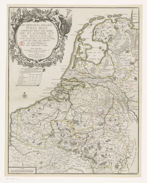
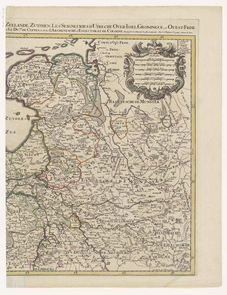
Franse kaart van de Republiek waarop de veroveringen van de Franse koning zijn aangegeven, 1672 1672
0:00
0:00
anonymous
Rijksmuseum
drawing, graphic-art, ink, engraving
#
pen and ink
#
drawing
#
graphic-art
#
baroque
#
pen illustration
#
pen sketch
#
old engraving style
#
landscape
#
ink line art
#
ink
#
pen-ink sketch
#
botanical drawing
#
pen work
#
engraving
#
botanical art
#
intricate and detailed
Dimensions: height 448 mm, width 570 mm
Copyright: Rijks Museum: Open Domain
Curator: Here we have a fascinating French map of the Dutch Republic dating back to 1672. It’s intriguing, a web of borders etched in ink by an anonymous hand. I'm especially interested in how this era’s cartography blends emerging scientific accuracy with potent political messaging. Editor: Wow, talk about dense! At first glance, it feels less like a helpful guide and more like visual white noise. Like trying to find your car in a jam-packed parking lot – where do you even start? But there's an underlying beauty too. Curator: That intricacy speaks volumes. Consider the era: the Dutch Republic was facing invasion. Each line, each placename becomes a marker of power, resistance, or perhaps loss. Note the title cartouche—it’s practically overflowing with symbolic devices, flags, coats of arms. These weren't mere decorations; they communicated allegiances and aspirations. Editor: Absolutely. You’re making me see it in a new light. It's like the cartographer knew their audience had a different relationship with maps. I’m used to digital navigation where the whole world fits on a screen; back then, this level of detail wasn’t just information, it was also a piece of art meant to be studied and admired, even as an assertion of identity and threatened sovereignty. Curator: Precisely! And consider the very materials. The ink itself, the engraved lines pressed onto paper…it embodies permanence. An attempt to fix a fleeting political landscape onto something lasting, creating a kind of cultural memory. You see, even its rendering has a narrative depth, almost literally grounding anxieties and power struggles into the physical earth. Editor: You've got me thinking about what was happening when it was made—like trying to map shifting sands, capturing something essentially unstable, this reminds me that borders aren’t solid, tangible things at all; they're constructs of conflict and negotiation. The act of charting becomes a political statement in itself. It begs us to think—who makes the maps? And for what ends? Curator: Exactly! This map becomes less about geography and more about ideology. Looking at the detailed pen work is an opportunity to contemplate the relationship between land, power, and identity at a very turbulent moment in history. Editor: This really has transformed my perception. From something initially overwhelming, I see layers of meaning, fragile strength expressed through cartography. I guess even maps can be mirrors reflecting back more than just location.
Comments
No comments
Be the first to comment and join the conversation on the ultimate creative platform.
More like this