drawing, ink, pen
#
drawing
#
pen sketch
#
ink
#
pen
Dimensions: 8 × 12 1/2 in. (20.3 × 31.8 cm) (image)9 3/4 × 13 in. (24.8 × 33 cm) (sheet)17 9/16 × 21 1/2 × 1 1/8 in. (44.6 × 54.6 × 2.9 cm) (outer frame)
Copyright: Public Domain
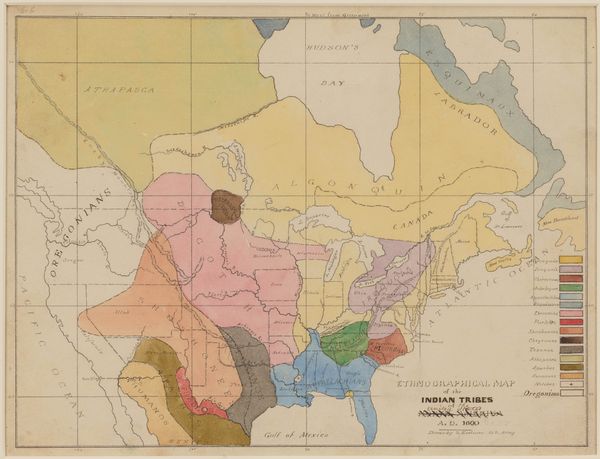
Editor: Here we have "Map Showing the Present Boundaries of the Ojibwa," a pen and ink drawing made by Seth Eastman in 1851. The soft hues give it an almost dreamlike quality, even though it depicts quite rigid borders. I'm curious, what catches your eye about this particular piece? Curator: Well, you know, maps are like little time capsules, aren't they? This isn’t just geography; it's a snapshot of power, perception, and, sadly, displacement. Imagine Eastman, an American military officer, creating this "objective" record, yet inherently biased by his position and the era's expansionist ideologies. Do you feel the weight of that perspective layered onto the landscape? Editor: I hadn't really thought about the artist’s role as an active agent like that, but I think I get what you mean... it almost feels like a document of a transaction in progress, even a conquest. So, what stories do you see whispered between those inked lines and borders? Curator: Oh, countless! I see the Ojibwa, their traditional lands meticulously outlined, perhaps with a hint of… defiance? And consider the other tribes named, each entangled in this cartographic web. Each line holds generations of history, treaties made and broken, promises whispered and forgotten. What do you make of the way he includes Lake Superior, the waterways snaking all across this territory, are they merely picturesque? Editor: Well I am struck that it does serve a purpose. Seeing the emphasis given to the bodies of water it becomes clear just how integral they must've been. Perhaps it also speaks to the way each indigenous group utilized it? I never would have given much thought to it. Curator: Precisely! And how fascinating that it's rendered with the tools and aesthetics of a colonizing force. Food for thought on whose story gets told and how. Thank you for that observation! Editor: Absolutely, thanks to you as well! I definitely see more in this piece than I initially did. The interplay between the starkness of its historical context and Eastman's approach, makes it much more evocative and affecting.
Comments
minneapolisinstituteofart about 2 years ago
⋮
U.S. Army Captain Seth Eastman was a trained artist who served twice on the frontier at Minnesota’s Fort Snelling, from 1830 to 1832 and again from 1841 to 1848. He loved map-making and even wrote a textbook on topographical drawing used at West Point, his alma mater. This work belongs to an extensive series that he made between 1849 and 1855 to illustrate Henry Rowe Schoolcraft’s monumental study "Historical and Statistical Information Respecting the History, Condition, and Prospects of the Indian Tribes of the United States" (Philadelphia: Lippincott, Grambo & Co., 1851-57). Mia’s 35 watercolors and drawings for the project represent an astounding array of subjects: muskrat hunting, fish spearing, pest control, rice gathering, maple sugaring, shelter, travel, medicine, mourning, dancing, civics, and topography. With such variety and Eastman’s well-informed clarity of depiction, they constitute an unparalleled visual account of native ways in our region.
Join the conversation
Join millions of artists and users on Artera today and experience the ultimate creative platform.
More like this