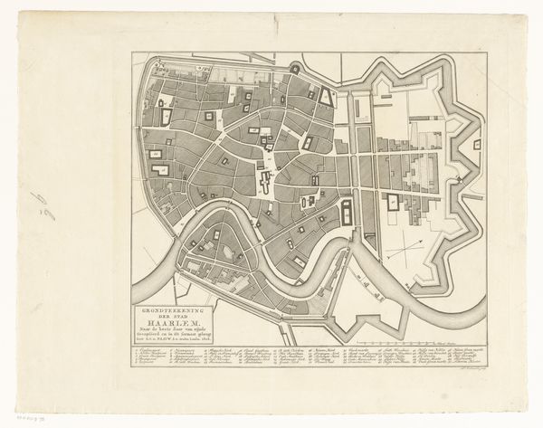
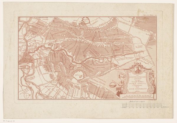
Plan der innern Stadt Wien mit dem Gebiete der Stadt-Erweiterung c. 1860s
0:00
0:00
silver, print, photography
#
16_19th-century
#
silver
# print
#
photography
#
geometric
#
cityscape
Dimensions: 34.5 × 39.3 cm (image/paper); 42.7 × 61.2 cm (album page)
Copyright: Public Domain
Curator: I find this map of Vienna from the 1860s fascinating, this silver print on paper, called "Plan der innern Stadt Wien mit dem Gebiete der Stadt-Erweiterung," captures a pivotal moment in the city's history. What are your initial thoughts? Editor: It gives me the sensation of looking at a ghost of a city, all faded lines and suggestive shapes. Like an architectural memory barely clinging to the paper. Almost unsettlingly sterile. Curator: I see what you mean, but its sterility speaks to a deeper purpose: pure representation. The stark geometric layout emphasizes rational planning and control over urban space. Notice how the anonymous artist contrasts developed and undeveloped areas with sharp tonal shifts. It’s an exercise in power and visual order. Editor: Power, yes, but also fragility. This wasn’t a fixed, unyielding plan; rather it was contingent. Almost aspirational in its precision. Do you sense the city that never came to be, or that transformed into something the mapmakers wouldn't recognize? Vienna’s beauty relies on moments not accounted for here, moments the plan can’t foresee. Curator: Precisely. It is a semiotic representation of the city, and not the city itself, divorced from sensory experiences like strolling the Ringstrasse or drinking coffee in a traditional Kaffeehaus, yet its objective form facilitates legibility. A system designed to inform decisions and navigate progress. Editor: Which begs the question: progress toward what? This ghostly blueprint only hints at social fabric. Who lives here? What are their experiences of place? These are stories whispered only through implication; the human dimension must be imagined and not displayed. Curator: True. However, as a tool for analyzing urban expansion, its objectivity transcends the personal. Look at how it anticipates Vienna’s future by rendering new districts in precise relation to existing landmarks; the grid, an emergent symbol of modernity. Editor: Ultimately, this isn't just a document but a potent aesthetic statement. The contrast between faded lines and darkened blocks; the tension between abstract ideal and concrete reality – makes it more captivating. Thank you, I’ll always imagine this “ghost plan” underlying everything in Vienna, from every cathedral to the curve of the Danube. Curator: Thank you! The image reminds us that maps aren’t mere reflections of reality; they shape and propose futures.
Comments
No comments
Be the first to comment and join the conversation on the ultimate creative platform.
More like this