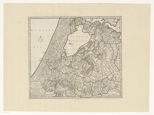
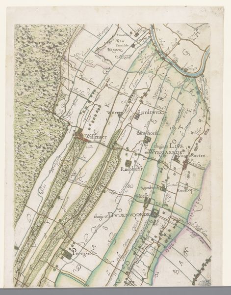
Kaart I. Het Hoogheemraadschap van Rijnland en het Haarlemmermeer met de werken tot Droogmaking (1 October 1843.) 1843 - 1861
0:00
0:00
print, engraving
# print
#
old engraving style
#
landscape
#
engraving
#
realism
Dimensions: height 755 mm, width 562 mm
Copyright: Rijks Museum: Open Domain
Curator: Here we have a fascinating engraved print titled "Kaart I. Het Hoogheemraadschap van Rijnland en het Haarlemmermeer met de werken tot Droogmaking (1 October 1843.)" It's dated between 1843 and 1861 and comes to us from the Rijksmuseum collection. What's your initial take on this work? Editor: It feels very detailed and technical at first glance. The color palette is muted, but there’s an intricacy in the lines that makes it compelling. Almost like a coded message, rather than a picturesque landscape. Curator: Absolutely. As the title suggests, it is a map. These types of maps document the efforts to drain the Haarlemmermeer. Land reclamation was a major undertaking in 19th-century Netherlands and this piece is deeply connected to the country’s history of hydraulic engineering and land management, very much about human ambition reshaping the physical world. Editor: I notice the visual language associated with maps—legends, keys, diagrams of waterways. Water here possesses symbolic value. It can represent nature's indifference but it also denotes the labor needed to establish new territories and infrastructures. The network of waterways and dikes are presented as vital for survival and commerce. Curator: Exactly. And the "Haarlemmermeer" wasn’t just any body of water; it was a lake that posed navigational and flooding problems. Draining it wasn't purely practical; it also became a symbol of national progress, efficiency, and control over nature. This map, intended to celebrate the success of this ambitious feat, was distributed among public entities. Editor: Thinking about symbolic association, it shows water giving way to land, mirroring a larger theme. You have this idea of controlling your environment, civilization triumphing over nature's chaos. There’s almost an alchemical feeling: transforming a liquid state into something solid and useful. A commentary on power relations. Curator: Precisely. It speaks to the evolving role of engineering and technology in shaping Dutch identity and territorial expansion, which were essential aspects of Dutch policy at the time. Also, notice the depiction of infrastructures and urban developments. Everything is about expanding influence. Editor: I'm struck by the print's power. Something technical and documentary carries these emotional and psychological depths when we delve deeper into its symbolic architecture. It transforms something topographical into social, economic, and emotional commentary. Curator: Yes, precisely. Through an understanding of the artwork’s context, this map presents a visual record, reflecting evolving notions of society and its relationship to its geographical environment. Editor: A wonderful dive into cartography’s visual storytelling!
Comments
No comments
Be the first to comment and join the conversation on the ultimate creative platform.
More like this