About this artwork
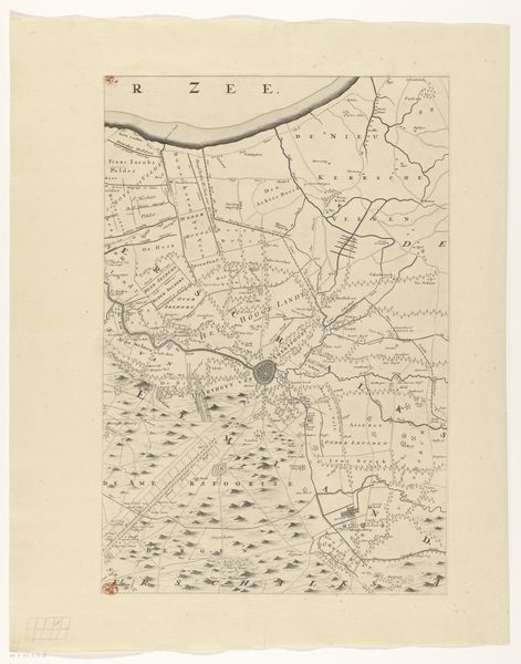
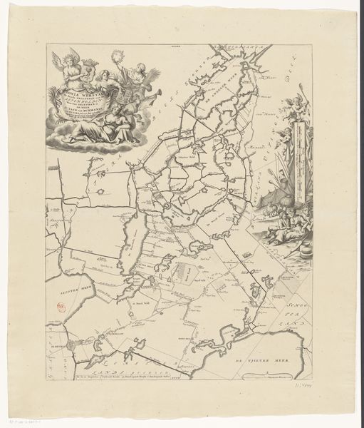
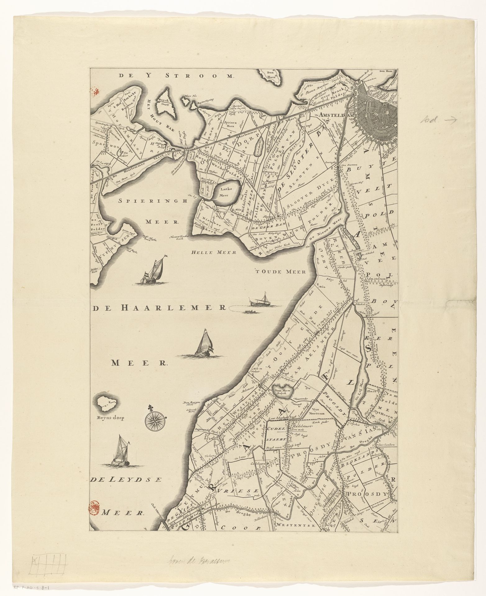
Curator: Let’s turn our attention to this print, "Kaart van de provincie Utrecht (eerste deel van boven)", or Map of the Province of Utrecht, created after 1696. It’s currently held here at the Rijksmuseum and is attributed to Thomas Doesburgh. Editor: Wow, there's a haunting beauty to this, don't you think? Like looking at a ghostly fingerprint left by a giant on the land. So delicate, almost ethereal, yet… purposeful. Curator: Indeed. This map, rendered as an engraving, provides an invaluable look into the geopolitical and socio-economic landscapes of the Dutch Republic during that period. It offers a lens into land use, territorial boundaries, and waterways that were integral to Dutch prosperity and power. Editor: You're so right! All those neat little squares scream order, control… I imagine farmers carefully marking every furrow they ploughed. A quiet tension in the lines too, perhaps some disputes simmering about who owns what! Am I totally projecting, do you think? Curator: Not at all. Mapping was, and still is, an assertion of power, intimately linked with governance, taxation, and even military strategy. What seems decorative to us, such as the sailing ships on the bodies of water, likely signified trade routes, naval presence, or perhaps even served a propagandistic function. Editor: I see! So these ships become like little power symbols floating there… it does put it all into perspective. I mean, at first it just struck me as a very detailed… well, drawing, really. Curator: Considering the era, before advanced surveying technologies, the precision is remarkable. What I find compelling is the implied human intervention--the imposing of structure onto a seemingly untamed landscape. It mirrors the ambitions of a society carving out its destiny. Editor: Makes you wonder about the folks behind these efforts—their sheer grit to take charge and alter things so vastly. Kinda makes you think about our mark-making on the world now, what kind of maps we’re etching with our lifestyles... Curator: Absolutely, the act of mapping inherently poses questions of whose perspectives are being prioritized. And in what ways that particular visualization might overshadow the lived experiences on that land, and the indigenous understanding of it. Editor: Okay, heavy. Alright, next piece? Before my head implodes contemplating the power dynamics of landmasses. Curator: A poignant reminder, though. Let’s keep those narratives in mind as we continue.
Kaart van de provincie Utrecht (eerste deel van boven)
after 1696
Thomas Doesburgh
@thomasdoesburghLocation
RijksmuseumArtwork details
- Medium
- print, engraving
- Dimensions
- height 557 mm, width 371 mm
- Location
- Rijksmuseum
- Copyright
- Rijks Museum: Open Domain
Tags
Comments
Share your thoughts
About this artwork
Curator: Let’s turn our attention to this print, "Kaart van de provincie Utrecht (eerste deel van boven)", or Map of the Province of Utrecht, created after 1696. It’s currently held here at the Rijksmuseum and is attributed to Thomas Doesburgh. Editor: Wow, there's a haunting beauty to this, don't you think? Like looking at a ghostly fingerprint left by a giant on the land. So delicate, almost ethereal, yet… purposeful. Curator: Indeed. This map, rendered as an engraving, provides an invaluable look into the geopolitical and socio-economic landscapes of the Dutch Republic during that period. It offers a lens into land use, territorial boundaries, and waterways that were integral to Dutch prosperity and power. Editor: You're so right! All those neat little squares scream order, control… I imagine farmers carefully marking every furrow they ploughed. A quiet tension in the lines too, perhaps some disputes simmering about who owns what! Am I totally projecting, do you think? Curator: Not at all. Mapping was, and still is, an assertion of power, intimately linked with governance, taxation, and even military strategy. What seems decorative to us, such as the sailing ships on the bodies of water, likely signified trade routes, naval presence, or perhaps even served a propagandistic function. Editor: I see! So these ships become like little power symbols floating there… it does put it all into perspective. I mean, at first it just struck me as a very detailed… well, drawing, really. Curator: Considering the era, before advanced surveying technologies, the precision is remarkable. What I find compelling is the implied human intervention--the imposing of structure onto a seemingly untamed landscape. It mirrors the ambitions of a society carving out its destiny. Editor: Makes you wonder about the folks behind these efforts—their sheer grit to take charge and alter things so vastly. Kinda makes you think about our mark-making on the world now, what kind of maps we’re etching with our lifestyles... Curator: Absolutely, the act of mapping inherently poses questions of whose perspectives are being prioritized. And in what ways that particular visualization might overshadow the lived experiences on that land, and the indigenous understanding of it. Editor: Okay, heavy. Alright, next piece? Before my head implodes contemplating the power dynamics of landmasses. Curator: A poignant reminder, though. Let’s keep those narratives in mind as we continue.
Comments
Share your thoughts