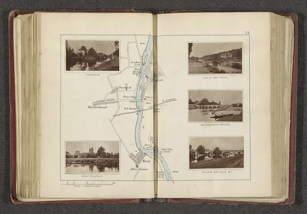
Kaart met twee afbeeldingen van plaatsen langs de Theems bij Sonning-on-Thames before 1879
0:00
0:00
drawing, paper, watercolor, pencil
#
drawing
#
sketch book
#
landscape
#
river
#
paper
#
watercolor
#
coloured pencil
#
pencil
#
cityscape
Dimensions: height 182 mm, width 227 mm
Copyright: Rijks Museum: Open Domain
Editor: So, here we have this curious page from an old book, "Kaart met twee afbeeldingen van plaatsen langs de Theems bij Sonning-on-Thames," which translates to “Map with two images of places along the Thames at Sonning-on-Thames.” It's before 1879, by Henry W. Taunt, and it combines pencil, watercolor, and what looks like colored pencil on paper. What strikes me is the strange juxtaposition of this precise, almost sterile map with these two evocative little landscapes tucked into the corners. What do you make of it? Curator: Oh, I’m immediately drawn to that tension you’ve picked up on! The rigid cartography versus those little whispers of the Thames...it’s as if Taunt is trying to contain the river's essence, nail it down with lines and measurements. The river refuses to be pinned, doesn't it? Like a dream stubbornly clinging to reality. It makes you wonder if the map isn’t actually more revealing for *what* it omits! Does the crispness of the line negate what is suggested in the dreamy images of this beloved Thames? Editor: That's a beautiful way to put it. I hadn't thought about it as the river "refusing to be pinned down." Maybe it is about the essence of a place beyond mere geography. Is he perhaps hinting at a dialogue between our human desire to control and the uncontrollable, flowing nature of... well, nature? Curator: Precisely! Or even the futility of it! I also find myself wondering about Taunt’s motivation for assembling this specific selection of visual data. There's a bit of an "artist-as-scientist" vibe. Are those precise measurements actually just emotional markers? Does that perspective shift the viewing experience for you? Editor: It does! Seeing them as potentially emotional markers casts the piece in a whole new light. Like the map isn't just about finding Sonning-on-Thames, but about *feeling* Sonning-on-Thames. Curator: Exactly. Next time I lose myself, maybe it's in a place just like this, one meticulously drawn by someone else so long ago! What have we discovered here, but just how powerfully nostalgia is portrayed by a map and memory.
Comments
No comments
Be the first to comment and join the conversation on the ultimate creative platform.
More like this