About this artwork
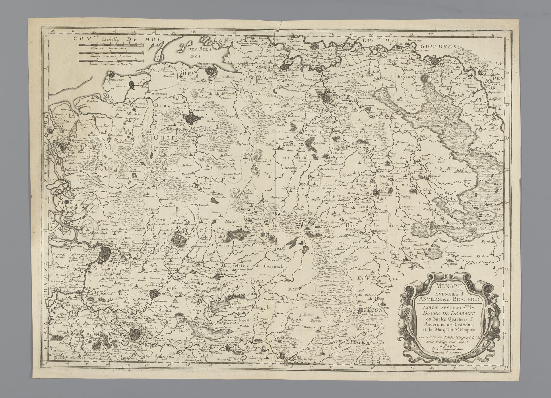
Editor: This is "Kaart van het noordelijk deel van het hertogdom Brabant," or "Map of the northern part of the Duchy of Brabant," dating from sometime between 1674 and 1730, by an anonymous artist. It’s an engraving in ink on paper. I’m struck by the detail—the sheer number of place names meticulously recorded. What symbols or meanings do you see embedded in this cartographic work? Curator: As an iconographer, I find these early maps fascinating, not just as records of geography but as encoded statements of power and identity. Think about what it means to define space, to claim territory through representation. Notice the ornamental cartouche – that decorative frame around the title. Does that elaborate design tell you anything about the intended audience or the cultural values it embodies? Editor: I see your point. It's much more decorative than a modern map, signaling prestige perhaps? Curator: Precisely. Consider the landscapes depicted. Are they accurate representations, or idealized visions projecting a specific narrative about the land? Look for repeated motifs – churches, castles, natural landmarks – and ask yourself what cultural memory they invoke, what continuities they establish. What does it mean that this map emphasizes some features over others? Editor: It's definitely selective in what it includes. So it's less about pure information and more about constructing a particular image of the region. The rivers, for example, are prominently displayed… maybe suggesting trade routes? Curator: Good observation! Rivers often symbolize connectivity and commerce, but they also act as borders, delineating power. Remember, maps are never neutral; they are always shaping our understanding of the world. Do you notice how the engraver utilized line thickness? Editor: Now that you mention it, some lines defining political boundaries are thicker than those showing, say, a stream. Curator: Maps provide an amazing intersection between history, art, and cultural identity. This makes me question the present ideas about countries and ownership. Editor: This really changed my perspective. I'll never look at a map the same way again!
Kaart van het noordelijk deel van het hertogdom Brabant
1674 - 1730
Anonymous
@anonymousLocation
RijksmuseumArtwork details
- Medium
- drawing, print, paper, ink, engraving
- Dimensions
- height 407 mm, width 558 mm
- Location
- Rijksmuseum
- Copyright
- Rijks Museum: Open Domain
Tags
Comments
Share your thoughts
About this artwork
Editor: This is "Kaart van het noordelijk deel van het hertogdom Brabant," or "Map of the northern part of the Duchy of Brabant," dating from sometime between 1674 and 1730, by an anonymous artist. It’s an engraving in ink on paper. I’m struck by the detail—the sheer number of place names meticulously recorded. What symbols or meanings do you see embedded in this cartographic work? Curator: As an iconographer, I find these early maps fascinating, not just as records of geography but as encoded statements of power and identity. Think about what it means to define space, to claim territory through representation. Notice the ornamental cartouche – that decorative frame around the title. Does that elaborate design tell you anything about the intended audience or the cultural values it embodies? Editor: I see your point. It's much more decorative than a modern map, signaling prestige perhaps? Curator: Precisely. Consider the landscapes depicted. Are they accurate representations, or idealized visions projecting a specific narrative about the land? Look for repeated motifs – churches, castles, natural landmarks – and ask yourself what cultural memory they invoke, what continuities they establish. What does it mean that this map emphasizes some features over others? Editor: It's definitely selective in what it includes. So it's less about pure information and more about constructing a particular image of the region. The rivers, for example, are prominently displayed… maybe suggesting trade routes? Curator: Good observation! Rivers often symbolize connectivity and commerce, but they also act as borders, delineating power. Remember, maps are never neutral; they are always shaping our understanding of the world. Do you notice how the engraver utilized line thickness? Editor: Now that you mention it, some lines defining political boundaries are thicker than those showing, say, a stream. Curator: Maps provide an amazing intersection between history, art, and cultural identity. This makes me question the present ideas about countries and ownership. Editor: This really changed my perspective. I'll never look at a map the same way again!
Comments
Share your thoughts