drawing, paper, ink
pen and ink
drawing
landscape
paper
ink
geometric
Dimensions: height 498 mm, width 633 mm
Copyright: Rijks Museum: Open Domain
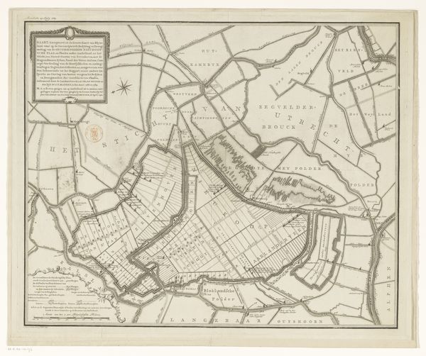
Curator: Isn't it remarkable how lines on paper can unlock entire worlds? This is "Kaart van de Ring van Putten (deel rechtsboven)", a map from between 1701 and 1738 by Gilliam van der Gouwen, created with pen and ink. Editor: It's like looking at a puzzle! So detailed and intricate. What I find intriguing is how it's more than just geographical; it feels almost like a portrait of a community. What do you see when you look at it? Curator: Ah, yes! It whispers stories, doesn’t it? Imagine the artist, meticulously charting every field, every waterway. The land itself becomes a character. Do you notice the variations in the ink? They almost hum with a personal vibration of the cartographer's intention and care. Editor: I see what you mean. The darker lines defining the waterways are definitely more assertive than the faint lines of the fields. So, were these maps seen as art back then? Curator: That’s the fascinating bit, isn’t it? Was van der Gouwen seeing himself as an artist or an artisan, painstakingly creating a vital tool for his community? Maps are usually objective and accurate, yet, through its landscape style, we get a clear subjective perspective. Editor: I guess the beauty lies in the blend, then. Curator: Precisely. Today, looking back at this historical artifact, its beauty sings loud as it embodies utility and a gentle personal signature. The perspective grants a sense of both intimacy and perspective. Don't you think? Editor: Definitely. I initially saw just a map, but now it feels like peering into someone's memory. Curator: Wonderful. It's about finding art everywhere, wouldn’t you agree? Even where we least expect it.
Comments
No comments
Be the first to comment and join the conversation on the ultimate creative platform.