print, etching, engraving
# print
#
etching
#
etching
#
cityscape
#
engraving
Dimensions: height 432 mm, width 515 mm
Copyright: Rijks Museum: Open Domain
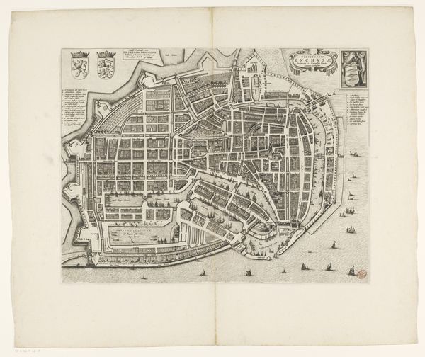
Curator: Here we have an interesting work: “Plattegrond van Enkhuizen,” a cityscape rendered through etching and engraving. It’s thought to have been made sometime between 1726 and 1766. Look closely; the details are incredible. Editor: My first impression? It’s a ghost of a place, a whisper from the past. All those tiny streets, those fortified edges. It feels… vulnerable. Curator: Vulnerable? Because of the precision, the way everything is laid bare for the viewer? Or the sea surrounding the whole cityscape? Editor: Precisely! Think about what maps represent. Power, control, knowledge… but also a desperate need to chart and contain. And water surrounding the image feels ominous. As if the city is circled, not secure. All the symbols together create the city's spirit. Curator: Interesting interpretation. This level of detail suggests civic pride. Each building precisely rendered, the docks bustling with implied activity... Isn’t this a projection of power, showing Enkhuizen’s significance as a trading port? Editor: Perhaps a desire for that image of power. The sea is a crucial element: ships both represent that trade strength, yet also underscore vulnerability to external forces. The compass is ever-present as an icon: you are never safe in a changing world. Also the lines themselves! An etching is fragile, easily damaged, it reminds that the reality represented is similarly at risk. Curator: A fair point about fragility, and I do see how the map contains the tension between representation and reality. Thinking about symbols, what stands out to you? Editor: For me it’s always those fortifications: stark visual signifiers of the human instinct for defense and survival. But isn’t that the essence of any map? To defend what you possess, to chart boundaries against the unknown. Even the orientation can point towards specific agendas: every stroke embodies narrative power and fear, every little engraving decision affects that feeling of tension in a big way. Curator: A city etched not just in ink, but in anxieties. It definitely puts a new spin on this old map. Thanks! Editor: And thanks to you: you made me see a cartographer more as an anxious guard, and less as a neutral recorder. A shift in perspective!
Comments
No comments
Be the first to comment and join the conversation on the ultimate creative platform.
More like this