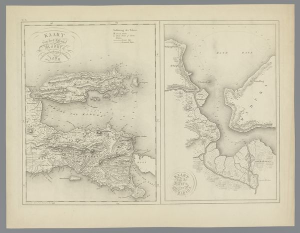
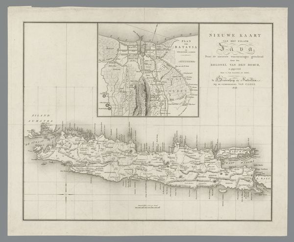
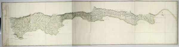
Kaart van Java waarop de verdeling van het land onder de Javaanse vorsten is aangegeven 1817
0:00
0:00
drawing, print, paper, ink, pencil, engraving
#
drawing
# print
#
asian-art
#
landscape
#
paper
#
ink
#
pencil
#
engraving
Dimensions: height 379 mm, width 533 mm
Copyright: Rijks Museum: Open Domain
Curator: Here, we're looking at "Kaart van Java waarop de verdeling van het land onder de Javaanse vorsten is aangegeven," or "Map of Java showing the division of land among the Javanese princes." It’s from 1817, created by C. van Baarsel en Zoon, employing pencil, ink, and engraving on paper. Editor: It feels so precise, almost clinical in its detail, but something about the light and shade evokes a strange stillness. Like a blueprint holding secrets. Curator: The clinical feel is deliberate. Cartography in this era wasn’t just about geography; it was a tool of colonial power. This map visualizes a power structure, the division of land among local rulers under colonial oversight. Editor: Absolutely. The act of mapping itself is an assertion of control, isn’t it? To name, define, and therefore, to possess. Who commissioned it? What were they hoping to achieve through its circulation? Curator: Good questions. Maps like these were often commissioned by the Dutch East India Company to consolidate their influence. By delineating territories, they could manipulate power dynamics between local leaders, facilitating resource extraction and control. Editor: So it’s less a neutral representation of the land, and more a strategic tool for social engineering, neatly packaged in a landscape style typical of the period. Curator: Exactly. The details are significant. The precise rendering of coastlines, rivers, and administrative divisions speaks to the colonizer's desire for order and legibility, erasing existing indigenous land management systems. Editor: And by creating a seemingly objective image, the map naturalizes a very subjective political reality, disguising the violence inherent in colonial governance. Were Javanese perspectives included at all? Curator: Unlikely, this map served primarily as a tool for the Dutch administration. Though indigenous knowledge would invariably inform its accuracy, the map’s purpose and final presentation catered exclusively to European interests. Editor: This is a stark reminder that art and visual representation can be weapons. Understanding the power dynamics at play allows us to unpack these layers of meaning and challenge the supposed neutrality of historical documents like these. Curator: Precisely. It invites us to reflect on whose stories are told, and how they're framed, reinforcing how important it is to acknowledge the biases within seemingly objective historical accounts.
Comments
No comments
Be the first to comment and join the conversation on the ultimate creative platform.
More like this