print, etching, engraving
#
neoclacissism
# print
#
etching
#
landscape
#
etching
#
engraving
#
realism
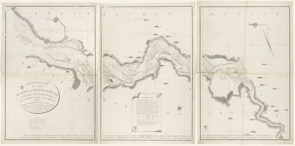
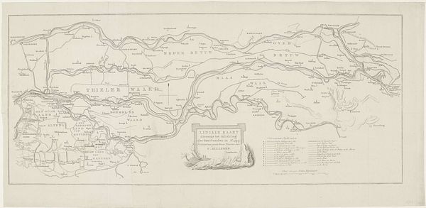
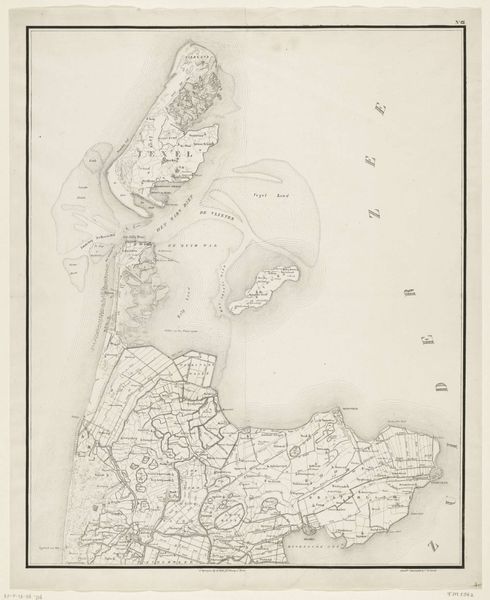
Dimensions: height 952 mm, width 650 mm
Copyright: Rijks Museum: Open Domain
Editor: This is "Kaart van de Westerschelde (tweede deel)," or "Map of the Western Scheldt (second part)" created in 1799 by E. Collin, using etching and engraving. The precision of the lines depicting the coastline and inland features is really striking. What's your take on this kind of historical cartography? Curator: Maps from this era were more than just geographical tools. They represented political power and economic interests. Who controlled the waterways, controlled trade, and to a great extent, the flow of information. Consider the placement of this map, who might have viewed it, and what message was intended in creating and displaying the boundaries so definitively? Editor: That’s interesting! I hadn’t thought about the power dynamic inherent in defining borders. It makes sense though, especially looking at the detail dedicated to the "Avertissement," almost like a declaration. How did the socio-political climate influence the production of these detailed prints? Curator: During the late 18th century, we see an upswing in Neoclassical aesthetics coupled with a fascination with Enlightenment ideals of reason and order. This map embodies that spirit of rational exploration and categorization of the natural world, don’t you think? The detailed rendering and scientific precision conveyed trustworthiness. It would legitimize territorial claims for the governing bodies of the time. Editor: That's a great point! I see the influence of those values now; the level of precision seems tied to this idea of rational, verifiable truth. Curator: And this level of precision, mass produced for a larger audience speaks to power on a grand scale, something the governing bodies likely appreciated. Looking at it from that angle, what’s your perspective now? Editor: I realize how the presentation and even the existence of a map like this, could shape public opinion and perception of a region. It highlights that even seemingly objective depictions of reality are loaded with societal values and intentions. Thank you. Curator: Exactly! And hopefully this has expanded our awareness of how maps like this one played a central role in shaping political landscapes.
Comments
No comments
Be the first to comment and join the conversation on the ultimate creative platform.
More like this