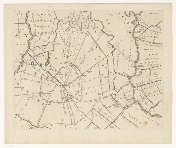
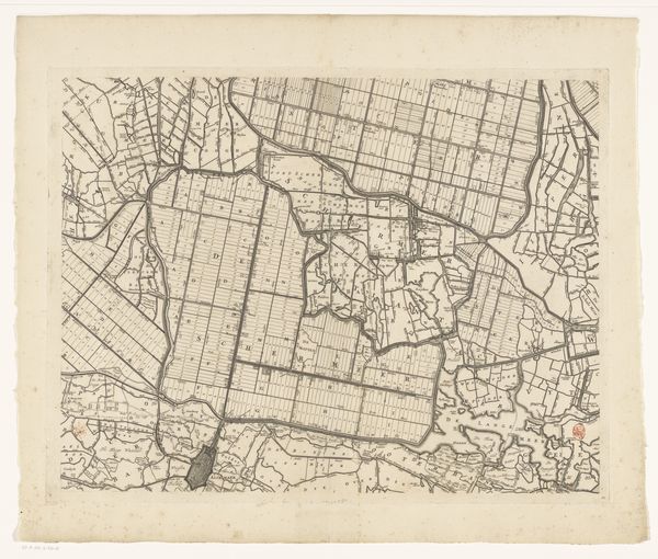
Kaart van het Hoogheemraadschap van Rijnland (twaalfde deel) 1647 - 1687
cornelisidanckerts
Rijksmuseum
drawing, graphic-art, print, etching, engraving
drawing
graphic-art
dutch-golden-age
etching
landscape
etching
engraving
Dimensions: height 454 mm, width 568 mm
Copyright: Rijks Museum: Open Domain
Curator: Looking at this, my first impression is how systematically ordered this landscape seems; almost a premonition of modern land management! Editor: You’re picking up on the aesthetic qualities, I immediately zoomed in on how this order emerged from contested territories and changing water politics of the time. Shall we unpack this? This is a section of the map "Kaart van het Hoogheemraadschap van Rijnland," by Cornelis Danckerts I. It’s a graphic work mixing etching and engraving dating from around 1647-1687. Curator: Ah yes, a fragment in time, rendered in ink and paper. I see this map brimming with symbolic intent; these lines, meticulously etched, they represent something deeper than mere geography. Editor: Precisely! These precise boundaries, dividing the land into neat parcels, represent not just physical space, but also legal claims, power structures, and economic interests in the 17th century. Notice how the waterways aren’t just natural features; they are carefully managed channels defining these demarcations of land. Curator: True. Water, so vital, here presented as controlled and geometric! The very act of mapping asserts dominion—a visual assertion of control. It also hints at an understanding of water’s potential for both life and destruction, very present at the time. Editor: Indeed! Think about it – these polders reclaimed from the sea required immense engineering and continuous upkeep. The map isn't just recording geography; it's revealing a social contract between people, and this particular environment. Curator: Yes, consider how land, typically yielding chaotic growth, is shown through a structured Dutch grid. There is a sense of deep societal control—almost the triumph of will over nature's disorder, captured through potent visual shorthand. Editor: Exactly. We can understand it today as not just a technical achievement but also a cultural document, filled with embedded values around productivity, organization, and communal governance of crucial resources like land and water. The map as propaganda almost! Curator: Absolutely! Beyond sheer cartography, it's a complex symbol—an ideology inscribed in lines, speaking volumes about humanity's relationship with our environment. Thanks for illuminating some layers of it with your historical perspective. Editor: The pleasure was all mine. This interplay between symbol and lived experience is precisely what makes studying these pieces so rich. Hopefully listeners can carry away both aesthetic impressions as well as insights into social forces embedded even within this simple map fragment.
Comments
No comments
Be the first to comment and join the conversation on the ultimate creative platform.