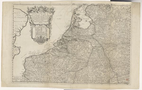
Kaart van de Republiek der Zeven Verenigde Nederlanden en een deel van het Heilige Roomse Rijk after 1680
0:00
0:00
carelallard
Rijksmuseum
graphic-art, print, engraving
#
graphic-art
#
baroque
# print
#
pen sketch
#
old engraving style
#
landscape
#
engraving
Dimensions: height 480 mm, width 825 mm
Copyright: Rijks Museum: Open Domain
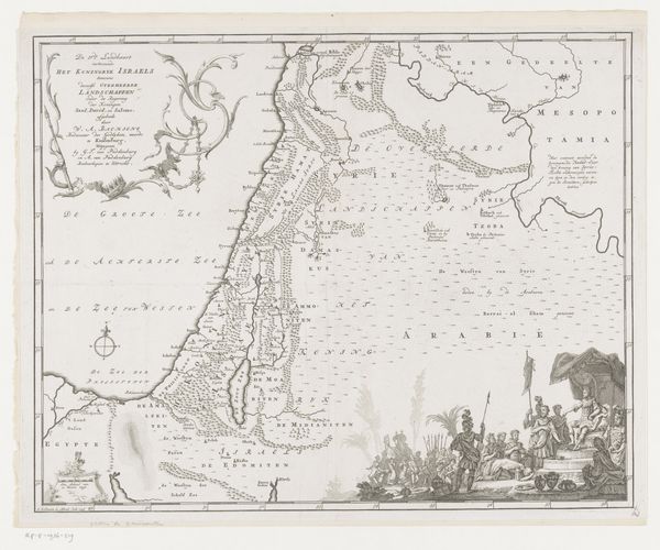
Curator: What a detailed creation. We're looking at "Kaart van de Republiek der Zeven Verenigde Nederlanden en een deel van het Heilige Roomse Rijk," or "Map of the Republic of the Seven United Netherlands and part of the Holy Roman Empire," an engraving by Carel Allard, dating from after 1680. It’s held here at the Rijksmuseum. Editor: Immediately striking is the precision of this piece. Look at the fineness of the lines! But the allegory… quite classical, quite imperial. Even for a republic, this feels like a projection of power, a carefully crafted declaration. Curator: Absolutely. The engraving style recalls older traditions of mapping as a form of statecraft. The cartouche at the top left isn’t merely decorative. Figures of justice, prosperity, military strength they speak to the aspirations and justifications of the Dutch Republic. Notice how they subtly dominate the geographic space. Editor: I see the desire for control, not only over the physical space depicted, but also the symbolic realm. Those classical figures almost sanctify Dutch ambitions, turning land into legacy. It's a Baroque display, but what is it trying to mask, or to further empower through an invented grandeur? Curator: The sea itself bears symbolic weight. Ships sail confidently and freely, showcasing Dutch maritime prowess, of course. Consider, also, the borders: quite clearly delineated, assertive. But there's always negotiation at play. The 'map' isn't merely recording, it's shaping how viewers perceive those borders, that sovereignty. Editor: Exactly! And consider how the land is presented. It’s not just geographic data; it's a claim. By detailing cities, rivers, and regions, the map makes tangible this abstract notion of ‘the Republic.’ But who is being represented in this vision? Whose stories are missing from this carefully constructed narrative of nationhood? Curator: A question worth asking, definitely. These historical maps, beautiful as they are, served very particular agendas. They're documents of power, revealing much about how societies wished to be seen – or to see themselves. Editor: It leaves me thinking about the weight we give maps even today – the narratives they reinforce, the spaces they overlook. This piece serves as a potent reminder of the stories maps tell, and crucially, those they intentionally leave out.
Comments
No comments
Be the first to comment and join the conversation on the ultimate creative platform.
More like this