drawing, print, ink, pen, engraving
#
drawing
#
aged paper
#
toned paper
# print
#
pen sketch
#
sketch book
#
landscape
#
personal sketchbook
#
ink
#
geometric
#
ancient-mediterranean
#
pen-ink sketch
#
pen and pencil
#
pen work
#
sketchbook drawing
#
pen
#
sketchbook art
#
engraving
Dimensions: height 105 mm, width 145 mm
Copyright: Rijks Museum: Open Domain
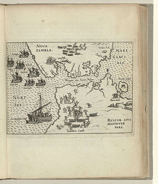
Curator: This map, titled "Kaart van Nova Zembla, 1594", created around 1598, offers such a fascinating insight into early cartography. I notice its depiction of the Northern territories with ships and creatures dotting the seas. What strikes you initially? Editor: I’m struck by how different this map is from the digital ones I'm used to! It's an engraving with delicate pen work. I am also very curious about how this map was used at the time and how accurate it was! How do you interpret this work in the context of its time? Curator: It’s important to recognize that this map is not just a geographical tool; it is an assertion of power and knowledge. Maps like these shaped how Europeans understood and interacted with the world, legitimizing exploration and colonization. Editor: So, you are saying that in the history of maps, these works were actively influencing the colonizer's view and behavior. The lines and images are not neutral. Curator: Precisely. The visual choices, the inclusion of sea monsters, the decorative elements—they all contributed to a narrative. A narrative that emphasized the exotic, the unknown, and often, the need for European intervention and 'civilization', especially because a new sea route to Asia was believed to be just around the corner. What questions does this raise for you about how we understand historical representation? Editor: I’m wondering about whose perspective is centered here? How might indigenous populations have understood and mapped these same spaces differently? It’s sobering to think about what is being erased. Curator: Exactly! By acknowledging these erasures, we start to deconstruct the authority embedded within these historical documents and gain a fuller understanding. Editor: It definitely makes me rethink how I see maps and who has the power to create them, even today. Curator: And how this reflects power dynamics, control and knowledge - something we can and should question even now.
Comments
No comments
Be the first to comment and join the conversation on the ultimate creative platform.
More like this