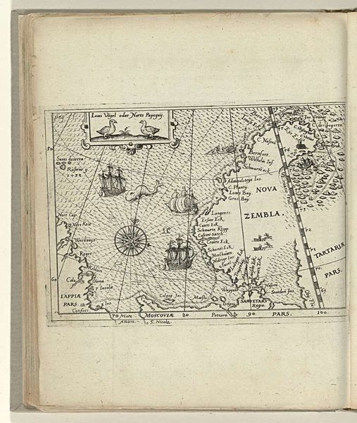
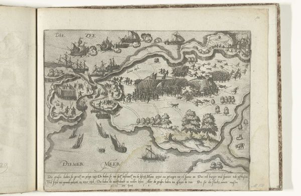
Kaart van de Russische kust met de stad Kola en het eiland Kildin, 1597 1598
0:00
0:00
anonymous
Rijksmuseum
drawing, print, paper, ink, engraving
#
drawing
#
aged paper
# print
#
pen sketch
#
sketch book
#
landscape
#
paper
#
form
#
11_renaissance
#
personal sketchbook
#
ink
#
sketchwork
#
pen-ink sketch
#
line
#
pen work
#
sketchbook drawing
#
storyboard and sketchbook work
#
sketchbook art
#
engraving
#
miniature
#
realism
Dimensions: height 105 mm, width 145 mm
Copyright: Rijks Museum: Open Domain
Editor: Here we have “Kaart van de Russische kust met de stad Kola en het eiland Kildin,” or “Map of the Russian coast with the city of Kola and Kildin Island," from 1597, by an anonymous artist. It's an engraving, ink, and possibly also a drawing, on paper. I’m struck by how detailed this miniature map is, considering the time period. What stands out to you? Curator: This map offers a fascinating window into the intersection of cartography, exploration, and power during the late 16th century. The detail, as you noted, is impressive, but also consider the context. Who commissioned this map? What purpose did it serve? Was it intended for navigation, military strategy, or perhaps to assert territorial claims? Editor: That's interesting! So, its significance lies not just in the depiction itself, but also in its socio-political use? Curator: Precisely. Maps weren't just neutral representations of space; they were instruments of power. This map, like others of its time, played a role in shaping European understanding of, and engagement with, the Russian coast. Notice the inclusion of figures within the map itself. What might their presence signify? Are they explorers, inhabitants, or symbolic representations of the region's resources or potential? Editor: Maybe they're intended to signal who inhabits the region. Also, they signal what "resources" (people) are there, from a Western European perspective. So, this "artwork" tells the story about exploration and control more than simple directions from point A to point B. Curator: Exactly. And this also gives us a new perspective on the visual representation of other cultures, during periods of intense territorial expansion and emerging colonial governance. It's also worth questioning what biases or omissions might be present, reflecting the interests of those who commissioned or created the map. Editor: This makes me think differently about how something as simple as a map is so laden with cultural and historical meaning! Thank you!
Comments
No comments
Be the first to comment and join the conversation on the ultimate creative platform.
More like this