drawing, print, ink, engraving
#
drawing
#
baroque
# print
#
old engraving style
#
landscape
#
ink
#
engraving
Dimensions: height 222 mm, width 317 mm
Copyright: Rijks Museum: Open Domain
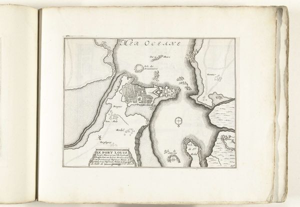
Curator: Welcome, everyone. Today we are looking at a fascinating object titled, "Kaart van de baai van Porto Bello in Panama," dating from around 1702, created by an anonymous artist. It’s an engraving, meticulously rendered in ink. Editor: It has such an evocative quality, the detail is just so striking in this small image. The density of line work, it creates a very immediate and tangible sense of place. Curator: Indeed. It offers a window into the geo-political strategies of the time. Consider Porto Bello’s vital role for the Spanish Empire. This map wasn't simply about navigation, but about power. Maps like these allowed nations to visualize, strategize, and claim territories. The very act of mapping was a declaration. Editor: Absolutely. Looking closer at the radiating lines—these navigational aids are not merely functional. They also serve as compositional anchors. See how they pull your eye across the watery expanses towards land, dictating the reading of space? The contrast of land masses versus negative space is a masterclass in graphic organization. Curator: Maps from this era played a crucial role in shaping the historical trajectory. Control over these strategic ports often decided naval dominance and control of the flow of resources. Editor: You can feel the meticulous intent, though. The engraver's conscious decision to use hatching techniques around the islands to differentiate them—brilliant, subtle textural variations that breathe life into a static depiction. Curator: A detail such as the location’s name tells a story of conquest, of course. Its placement centrally ensures a reminder of Spanish influence even within an ostensibly neutral navigational aid. Editor: Seeing this makes me appreciate the artist's delicate hand and intentional approach. It’s like deciphering a visual code where symbols of the period intermingle with observations. Curator: Precisely. In viewing this piece, we have glimpsed an intersection of political aspiration and an artistic articulation from the early 1700's. Editor: I leave with a renewed sense of cartography not just as representation but interpretation.
Comments
No comments
Be the first to comment and join the conversation on the ultimate creative platform.
More like this