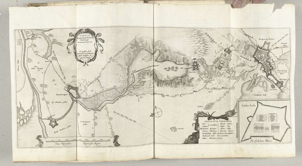
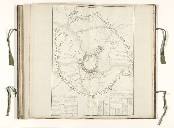
Kaart van het ondergelopen gebied tussen de Spaanse posities en het legerkamp van Maurits, 1624-1625 1625 - 1626
0:00
0:00
anonymous
Rijksmuseum
drawing, print, paper, ink
#
drawing
#
dutch-golden-age
# print
#
landscape
#
paper
#
ink
#
cityscape
Dimensions: height 252 mm, width 357 mm
Copyright: Rijks Museum: Open Domain
Curator: Let's look at this fascinating piece titled, "Kaart van het ondergelopen gebied tussen de Spaanse posities en het legerkamp van Maurits, 1624-1625," made between 1625 and 1626. It's a map, meticulously drawn with ink on paper and printed. Editor: It's amazing to see a landscape depicted in such a strategic way. What really strikes me is how the map illustrates the relationship between the natural world and military strategy. How do you interpret this work? Curator: I see layers of cultural memory embedded in these lines. It's not merely a geographical document; it’s a representation of power dynamics. Notice the visual language used for the Spanish positions versus Maurits' camp. What do these distinctions suggest about the perceived strength and intentions of each side? Editor: That’s a good point. The Spanish positions seem more fortified, while Maurits' camp is indicated through lettering only and shown much further back. Almost as if suggesting their advance was more strategic. Curator: Precisely! Think about the psychological impact such imagery might have had on contemporaries. Maps weren't just tools for navigation; they were instruments of propaganda. Each symbol, from the rivers to the fortifications, contributes to a narrative, reinforcing collective beliefs about safety, threat, and national identity. How does understanding this shift your perspective? Editor: It makes me think about how even seemingly objective images are loaded with subjective viewpoints. Curator: Indeed. And those viewpoints shaped the very culture of the time. Understanding these symbolic languages allows us to connect with the past in a much richer, more meaningful way. Editor: I never thought a map could reveal so much about the culture that created it. Curator: That's the power of iconography! Everything from the lines of a building to the direction of a river tells a story.
Comments
No comments
Be the first to comment and join the conversation on the ultimate creative platform.
More like this