graphic-art, print, etching, paper, engraving
#
graphic-art
#
baroque
# print
#
etching
#
paper
#
coloured pencil
#
engraving
Dimensions: height 180 mm, width 264 mm
Copyright: Rijks Museum: Open Domain
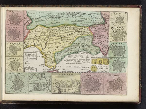
Curator: Here we have an intriguing map titled "Kaart van Catalonië," created anonymously sometime between 1700 and 1735. It’s a composite of engraving and etching, printed on paper. What strikes you first? Editor: Well, immediately I'm drawn to the series of what appear to be star-shaped citadels framing the central map. Each of them seem to carry so much loaded imagery related to protection, strategy and maybe even fear? Curator: That's a sharp observation. The inclusion of those fortresses speaks to the political and military landscape of the era. The printing process itself, combining etching and engraving, suggests a meticulousness, and a collaborative effort in production that underscores the map’s value. Editor: Absolutely. And how fascinating that the mapmaker chose these particular symbols. Those aren’t just generic forts; each is uniquely rendered, perhaps indicative of their specific defensive strategies or maybe of events from local lore during the conflicts that dominated early modern Europe? It's as if the region itself is a series of protected vital organs, all strategically linked. Curator: Exactly. Think of the labour involved, from the initial design to the transfer onto the metal plates and then finally, the press itself. Maps such as this one weren't mere representations; they served very practical functions in both military strategy and civil administration. The subtle colouring also adds a layer of value, both visually and economically, since this would have required additional resources and skills. Editor: I imagine people pouring over this map trying to figure out if the balance of these star fortresses would keep enemies at bay. Maps were much more than simply geographic tools back then. They held beliefs about collective anxiety, offering assurance in chaotic eras. They project not only space, but also power. Curator: I completely agree. By understanding the map's function as both object and symbol, we gain a better appreciation of the complex web of artisanal practice, trade and governance in early modern Europe. Editor: A journey charted not only on paper, but within our shared cultural memory. Curator: A perfect way to put it.
Comments
No comments
Be the first to comment and join the conversation on the ultimate creative platform.
More like this