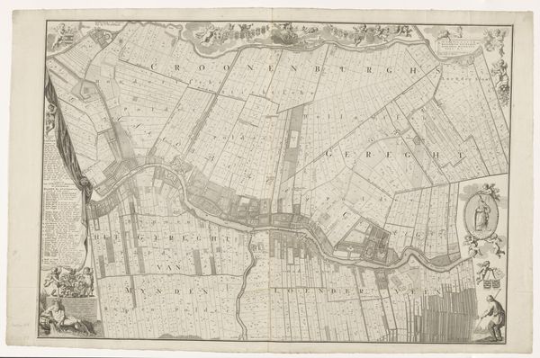
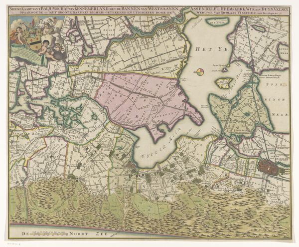
Kaart van de Buiksloter-, Broeker- en Bijlmermeerpolder 1628 - 1652
0:00
0:00
claesjanszvisscher
Rijksmuseum
print, etching
#
dutch-golden-age
# print
#
etching
#
landscape
#
etching
#
cityscape
Dimensions: height 269 mm, width 472 mm
Copyright: Rijks Museum: Open Domain
Editor: Here we have "Kaart van de Buiksloter-, Broeker- en Bijlmermeerpolder," created sometime between 1628 and 1652 by Claes Jansz. Visscher. It's a printed etching. What strikes me immediately is how…orderly everything appears. The polders are so neatly divided. What story do you think this map tells? Curator: Ah, yes, it's a world captured and tamed, isn't it? Imagine, a time when maps weren't just about knowing where you *are*, but also about asserting control over the land, literally shaping it to your will. The Dutch Golden Age was a period of incredible ingenuity but also this relentless drive to master their environment. Look at how the water is almost an afterthought – a wild scribble outside the neatly organized fields. Do you sense the ambition humming beneath the surface? Editor: Definitely. It’s almost a little unsettling, the way the land is presented as this blank slate ready to be divided. But I also notice the small details, the tiny houses and windmills sprinkled around. Curator: Exactly! Those little vignettes are clues. This map isn’t just about lines on paper, is it? Think of those windmills turning, grinding the earth to their rhythm, the people going about their lives within those neat divisions. It’s a portrait of a society being built, one painstakingly reclaimed field at a time. The act of mapping becomes an act of creation and hope, wouldn’t you say? Editor: That makes me see it in a completely different light! I was so focused on the stark lines and divisions that I missed the hints of life embedded within. I think what struck me before as control is now, also about ambition, and forward motion. Curator: Well said, an image reflecting not just the ambition but also the cost of ambition! A wonderful perspective.
Comments
No comments
Be the first to comment and join the conversation on the ultimate creative platform.
More like this