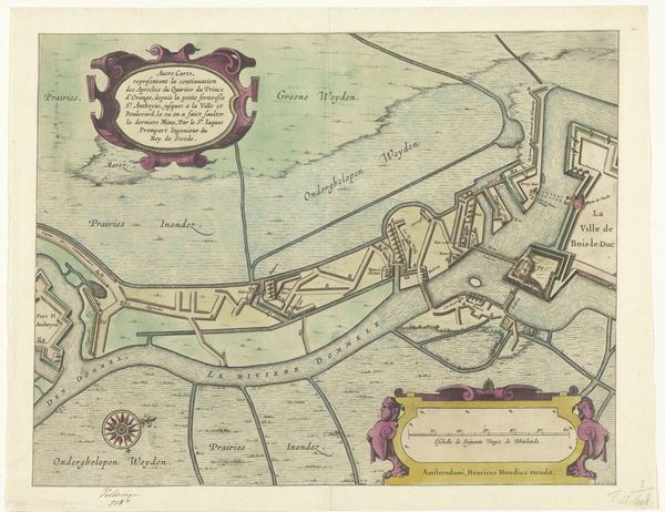
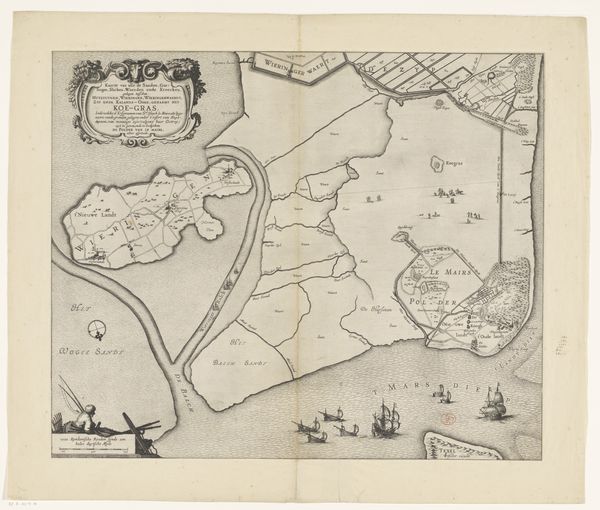
Loopgraven van het Staatse leger onder Ernst Casimr, tot aan de stad tijdens het beleg van Den Bosch, 1629 1629 - 1630
0:00
0:00
print, etching, intaglio, engraving
#
baroque
#
dutch-golden-age
# print
#
etching
#
intaglio
#
cityscape
#
engraving
Dimensions: height 291 mm, width 374 mm
Copyright: Rijks Museum: Open Domain
Curator: Standing before us is a rather fascinating piece, dating back to around 1629-1630. It's an etching and engraving—a print, really—that captures the siege of Den Bosch. The piece is called "Loopgraven van het Staatse leger onder Ernst Casimir, tot aan de stad tijdens het beleg van Den Bosch, 1629." Editor: Oh, immediately, it strikes me as incredibly detailed. Like looking at a blueprint for war. There's something unnerving about the precise lines, the geometric shapes cutting across the landscape. It feels almost clinical, despite depicting a scene of conflict. Curator: Exactly. It's a birds-eye view, almost map-like. You see the entrenchments, the layout of the siege lines snaking their way toward the city. There's an almost obsessive quality in the meticulous rendering of each line and contour. The tiny human cost is utterly invisible here; the artist seems completely preoccupied with the mechanics. What do you make of the baroque ornamentation, for instance, above the legend? Editor: That feels very much of the period—a kind of uneasy alliance between brutal utility and aristocratic flair. The little flags and ribbons, even the font, feels almost sarcastic juxtaposed with this machinery of war. Flags as marketing. There is so much here about imposing dominance. You have "Bois le Duc," meaning 'forest of the Duke.' The symbols around place, ownership and rule all coming into play through this strange map-artwork. The use of intaglio – the printing process where the image is cut into a surface and the ink sits below – further emphasizes the cutting effect of the state’s war apparatus into the landscape. Curator: It is quite stylized, definitely not a photorealistic representation. The pale washes of color are interesting too. There's a coolness to it all, further reinforcing the detachment. Editor: It feels very constructed, as though this whole endeavor of mapping and war were a feat of abstract engineering and control, almost divorced from the actual grit and violence on the ground. Seeing it today—especially after centuries of evolving perspectives on conflict— it’s interesting how a seemingly functional image can convey something profound about ambition, power and representation. I have to say, despite the age of this piece, it's strangely unnerving! Curator: Indeed. It is fascinating to reflect on the shifting perception of these forms of image, their original communicative purpose as cartography transforming to one that gives space for quiet meditation and reflective understanding of war.
Comments
No comments
Be the first to comment and join the conversation on the ultimate creative platform.
More like this