print, etching, engraving
#
baroque
# print
#
etching
#
landscape
#
engraving
Dimensions: height 430 mm, width 608 mm
Copyright: Rijks Museum: Open Domain
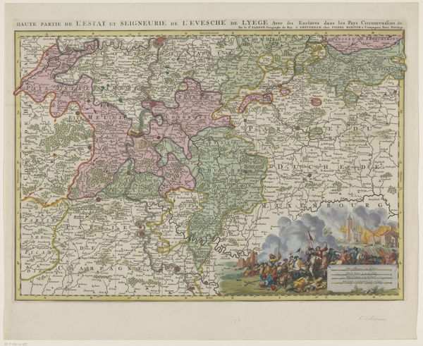
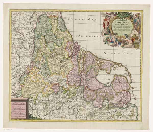
Editor: Here we have "Kaart van het prinsbisdom Luik," or "Map of the Prince-Bishopric of Liège," an etching and engraving printed sometime between 1696 and 1719. It has such a clear cartographic purpose, and yet the little tableau on the left suggests a narrative—what do you see in this piece? Curator: This map isn't simply a neutral depiction of territory; it's a powerful statement about ownership, control, and perhaps even contested power. Look at that tableau. The figures aren't just decorative. I wonder, how might it speak to issues of power and vulnerability at this historical juncture? The bodies lying prostrate suggest perhaps violence or submission? Editor: That's an interesting take, I hadn't considered the power dynamics so overtly. I focused on the colours of the landscapes. How do those tones impact our interpretation? Curator: Exactly, colour isn't just aesthetic! Consider the regions marked so distinctly. What does the act of coloring these territories separately imply about their relationship to each other and to the central power of Liège? Are we seeing a visual representation of privilege, resource distribution, or perhaps even areas of conflict or resistance? Editor: So the artistry isn't just illustrative, but rhetorical? That makes me think about the function of art as propaganda. Curator: Precisely! Maps like these weren't just for navigation. They were tools used to assert dominance and shape perceptions. Who do you think was the intended audience, and what message were they meant to receive? Understanding its circulation helps us unpack how such images constructed identities. Editor: This definitely shifts how I see the map. It is much more complex than simply geographical. Thanks! Curator: Agreed, these visual texts demand that we scrutinize how art is complicit in expressing socio-political viewpoints and legitimising claims over lands.
Comments
No comments
Be the first to comment and join the conversation on the ultimate creative platform.
More like this