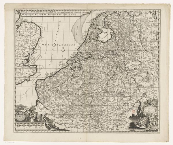
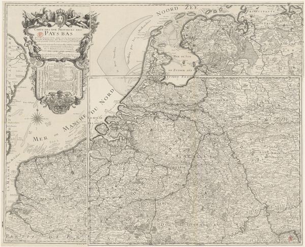
Historische kaart van Nederland met de gebieden van de Bataven en Friezen 1697 - 1725
0:00
0:00
print, engraving
#
baroque
# print
#
pen sketch
#
line
#
history-painting
#
northern-renaissance
#
engraving
Dimensions: height 317 mm, width 417 mm
Copyright: Rijks Museum: Open Domain
Curator: Look at this captivating historical map, titled "Historische kaart van Nederland met de gebieden van de Bataven en Friezen," created between 1697 and 1725 by Gerrit de Broen. It is a remarkable engraving. Editor: It feels so detailed, almost overwhelming. The density of information packed onto a single sheet! The lines seem delicate, precise and betray the labor-intensive process of engraving. Curator: Precisely. This map offers more than geographical data; it gives us a layered socio-political narrative. Notice the depiction of Batavia, an ancient region inhabited by Germanic tribes. We have to read the construction of these regions with a grain of salt. This visualization of a storied past serves the political present. Editor: I'm particularly struck by the material aspects of its creation. Engraving during this period involved a complex division of labor, from the draftsmen to the skilled engravers themselves. Considering the labor is fascinating when viewing such an image. Curator: Exactly, and this piece engages with concepts of national identity, territorial claims, and the construction of a historical narrative. How does it feel to engage with a manufactured history? One wonders how Indigenous people viewed such "documentation." Editor: It’s compelling to think about the circulation of these prints—as tools of knowledge but also objects of commerce and power. I bet there was much less access to cartography then than now, especially given the cost of materials, ink, and so on. This was only accessible to specific social groups and, thus, was most likely an emblem of the elite. Curator: It forces us to think critically about what and who these maps represented and perhaps excluded, given their inherently subjective and power-laden nature. So much hinges on the viewer to analyze this work and view it as not only an image of terrain. Editor: Absolutely. Looking at this print from the perspective of materiality and the labor embedded within really emphasizes the map not only as representation but as a tangible, constructed object. Curator: Reflecting on it, I'm drawn to the questions it poses about history, power, and representation. We must remain critical of all historical material as inherently shaped and interpreted to benefit specific people. Editor: Yes, it is a fascinating and challenging object that connects us to a crucial era. Looking at its process of production opens it to critical, urgent conversations that remain pressing.
Comments
No comments
Be the first to comment and join the conversation on the ultimate creative platform.
More like this