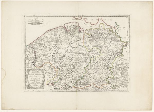
Nieuwe kaart van België; bevattende de Zuidelijke Department.n van het Koningrijk der Nederlanden en het Groothertogdom Luxemburg 1815
0:00
0:00
drawing, print
#
drawing
# print
#
history-painting
Dimensions: height 325 mm, width 403 mm
Copyright: Rijks Museum: Open Domain
Curator: Welcome! We are standing before a print entitled "Nieuwe kaart van Belgie," created around 1815 by C. van Baarsel en Zoon. It presents a detailed map of Belgium, including parts of the Netherlands and Luxembourg, showcasing their administrative divisions. Editor: It strikes me immediately as something quite delicate, almost frail, despite the rigid structure of the grid lines. The muted colors create a subdued atmosphere. Curator: Precisely. Note the use of fine lines and muted washes, establishing a system, a language for the era’s cartography and design, using the symbolic properties of shape. Semiotically, the arrangement guides our reading of geographic and political reality. Editor: How interesting to view cartography itself as a language. It suggests a carefully constructed perspective on land ownership, which has been, of course, anything but neutrally experienced. This was created just after the Napoleonic era, at a key moment in European boundary definition. Curator: Absolutely. The print’s formal elements, such as the subtle shading denoting topography, serve the state’s agenda, a display of the territories it wished to administer. Editor: You are spot on! Considering the sociopolitical context—the aftermath of Napoleonic rule—the detailed administrative boundaries project authority but also illustrate the reshaping of power dynamics after the Congress of Vienna. I find the details near Brussels revealing; the concentration of identifiable landmarks denotes how this map participates in solidifying a specific vision of geographical authority. Curator: The piece employs geometric precision to enforce spatial order; this aligns neatly with the empiricist spirit and the aesthetic preferences for symmetry of that period, a statement about controlling territory via rendering its physical structure intelligible. Editor: And such mapping was essential to governance. Without such representations of scale and topography, state building in the modern sense simply wasn't feasible. The inclusion of Luxembourg is another telling component—revealing the specific goals of the then recently established United Kingdom of the Netherlands. Curator: Ultimately, the work functions as both scientific record and symbol, uniting objective information with the desire to demonstrate control. Editor: Reflecting upon it, I’m struck how even seemingly technical depictions, such as maps, are deeply entwined with political projects.
Comments
No comments
Be the first to comment and join the conversation on the ultimate creative platform.
More like this