graphic-art, print, etching, engraving
#
pen and ink
#
graphic-art
#
aged paper
#
dutch-golden-age
# print
#
etching
#
old engraving style
#
etching
#
engraving
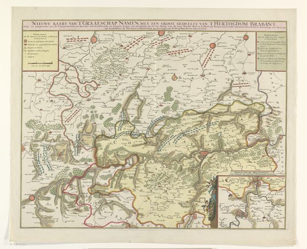
Dimensions: height 436 mm, width 575 mm
Copyright: Rijks Museum: Open Domain
Curator: So, here we have an etching and engraving simply called "Kaart van de kwartieren van Brussel, Leuven en Antwerpen," or Map of the regions of Brussels, Leuven, and Antwerp, dating back to 1684. It's currently held at the Rijksmuseum and the artist…well, they remain anonymous. Editor: My first thought is that it’s a rather unsettling kind of beauty. All those carefully etched lines… They almost feel like veins, or perhaps fault lines on the earth's skin, pregnant with unseen history and latent movement. Curator: It is indeed a very evocative image. It strikes me that the meticulous detail – you can practically trace the roads and waterways – would have been crucial for practical purposes back then, likely used for military strategy, commerce, and asserting territorial claims. But I like the idea that, on a deeper level, this representation became about inscribing ownership, dominance on a landscape. Editor: I can totally see that. I’m curious about those decorative cartouches framing the title and the legend. All those baroque flourishes… What do you think that excess conveys? Curator: I interpret that baroque framework as integral—far from just ornamentation. They declare authority, right? Almost a visual boast—"We know this land; we’ve mastered its representation." And the aged paper just amplifies the sense of history etched—quite literally—into this map. Editor: Absolutely. Speaking of what is etched, note that these symbols and tiny pictograms aren't neutral or objective, of course. Each little forest, village, river carries a memory, a meaning assigned by the cartographer and his patrons. Consider that these images communicate social order. A whole cultural perspective is rendered through the way land is shaped, used, and claimed. Curator: And in some ways, that is so much of what it is, isn't it? As well as history, this image suggests power, but now, the "how" has taken on even greater resonance in our age where maps have become so ubiquitous—consider global positioning systems, or digital elevation models that reveal landforms or surface characteristics of planets in unprecedented detail. The question isn’t just *where* anymore, but *why* and *how* do we continue to visually represent and navigate terrain at varying scales—near and far? Editor: And therein perhaps resides its lasting impact; "Kaart van de kwartieren van Brussel, Leuven en Antwerpen" still causes us to consider where the true lines of control and perspectives on landscapes reside, so very far beneath surfaces and symbols.
Comments
No comments
Be the first to comment and join the conversation on the ultimate creative platform.
More like this