About this artwork
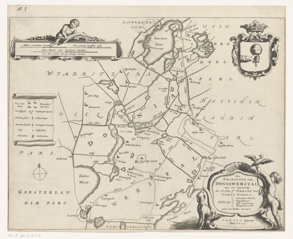
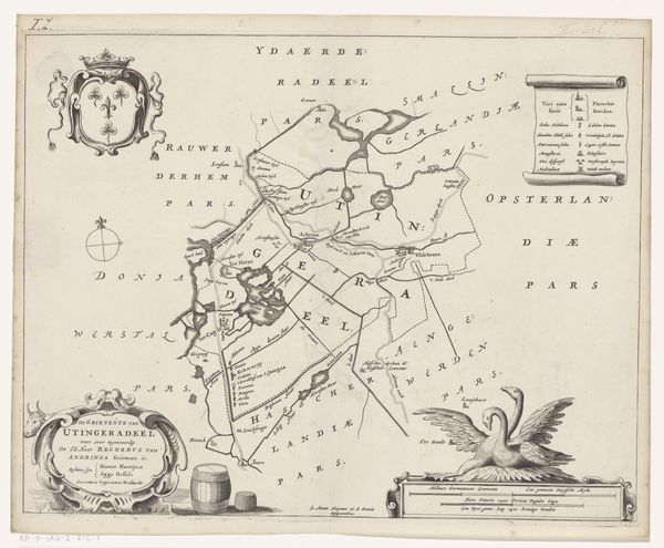
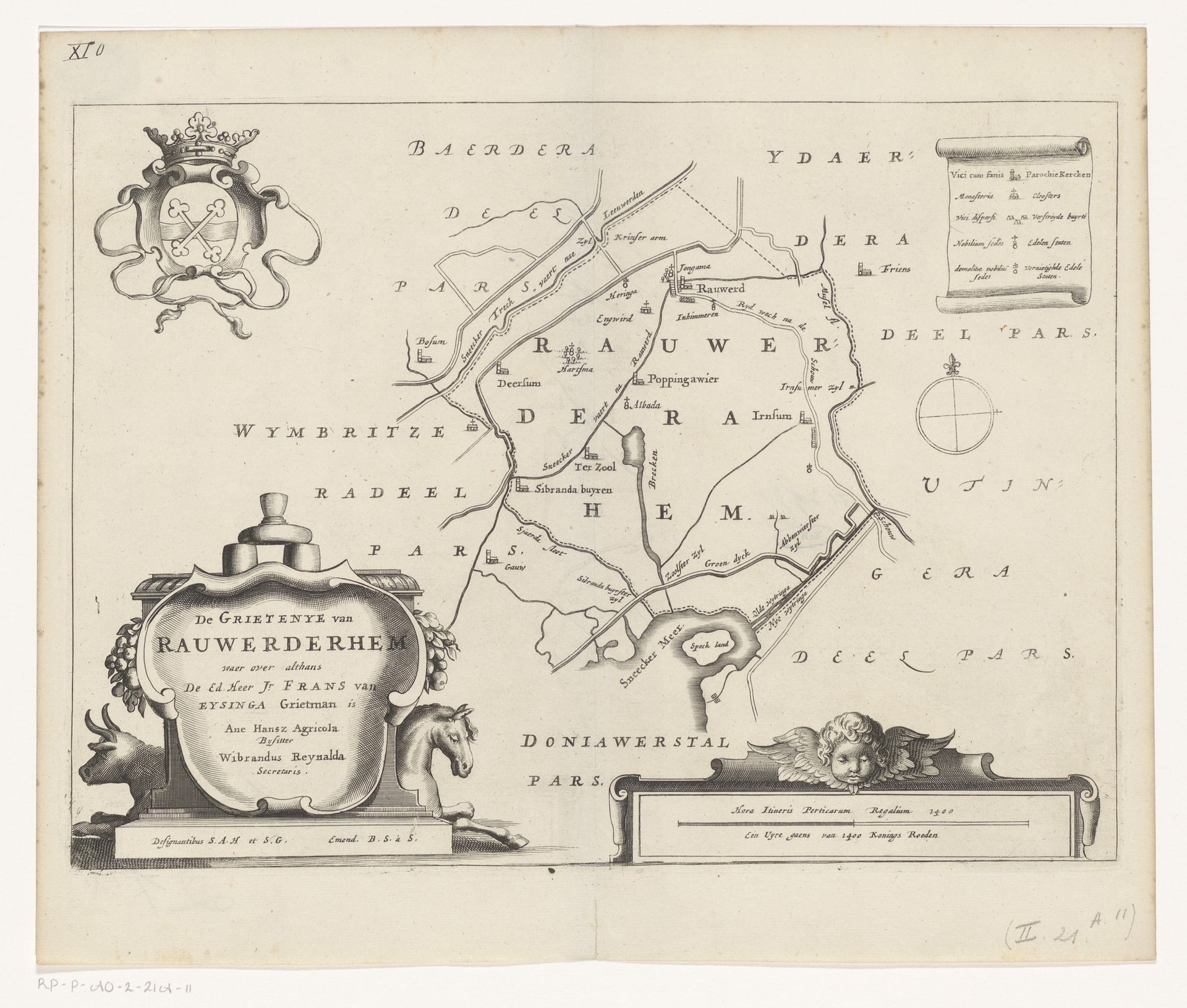
Curator: Before us, we have Jacob van Meurs's engraving from 1664, titled "Kaart van de grietenij Rauwerderhem," now held in the Rijksmuseum. This piece offers a fascinating glimpse into the geography and administration of a specific region during the Dutch Golden Age. Editor: My first impression? An elegant puzzle, or perhaps an architect's daydream. The lines are crisp and authoritative, yet the overall effect feels whimsical, even romantic. There’s a delicate balance of text and image that draws the eye. Curator: The engraving depicts Rauwerderhem, a former municipality in Friesland. What strikes me is how the map itself becomes a document of power. Note the elaborate coat of arms and decorative cartouches – these are not just aesthetic flourishes; they signal authority and ownership. This map was designed to not only show the landscape but also to reinforce social hierarchies. Editor: Precisely. And technically, consider the execution. The dense hatching to indicate the land’s topography and drainage… marvelous control of the burin. And see how strategically the script is placed to provide further dimension and texture, to guide the eye through this visual space. I would argue that the abstract forms alone lend a strong graphic quality, irrespective of its function as a map. Curator: Agreed, the level of detail is remarkable. However, that precision was vital to local governance. Land was wealth, knowledge of that land was power. By showcasing the meticulous administration of resources through its intricate design, it served to legitimize the sociopolitical order of the period. It projects this Dutch municipality as progressive and effectively administered. Editor: Still, the cherubic figure seems rather frivolous—an extraneous element which contributes to the print's overall ornate feel. It draws attention to itself unnecessarily in an attempt at sentimental depth—a very odd and overtly symbolic representation for such precise documentation. Curator: Perhaps, but even those seemingly superfluous flourishes spoke to the patrons of the time. Their taste, their expectations...it was all intertwined. For me, the enduring value lies in this intersection of cartography and propaganda – a beautifully crafted statement about land, power, and identity in the Dutch Golden Age. Editor: For me, it's the intersection of technical skill and artistry, rendering mundane geographical facts with an aesthetic elegance that transcends utility. Both interpretations can stand side-by-side, informed by distinct sets of concerns.
Artwork details
- Medium
- print, engraving
- Dimensions
- height 255 mm, width 346 mm
- Location
- Rijksmuseum
- Copyright
- Rijks Museum: Open Domain
Tags
dutch-golden-age
old engraving style
geometric
cityscape
engraving
Comments
No comments
About this artwork
Curator: Before us, we have Jacob van Meurs's engraving from 1664, titled "Kaart van de grietenij Rauwerderhem," now held in the Rijksmuseum. This piece offers a fascinating glimpse into the geography and administration of a specific region during the Dutch Golden Age. Editor: My first impression? An elegant puzzle, or perhaps an architect's daydream. The lines are crisp and authoritative, yet the overall effect feels whimsical, even romantic. There’s a delicate balance of text and image that draws the eye. Curator: The engraving depicts Rauwerderhem, a former municipality in Friesland. What strikes me is how the map itself becomes a document of power. Note the elaborate coat of arms and decorative cartouches – these are not just aesthetic flourishes; they signal authority and ownership. This map was designed to not only show the landscape but also to reinforce social hierarchies. Editor: Precisely. And technically, consider the execution. The dense hatching to indicate the land’s topography and drainage… marvelous control of the burin. And see how strategically the script is placed to provide further dimension and texture, to guide the eye through this visual space. I would argue that the abstract forms alone lend a strong graphic quality, irrespective of its function as a map. Curator: Agreed, the level of detail is remarkable. However, that precision was vital to local governance. Land was wealth, knowledge of that land was power. By showcasing the meticulous administration of resources through its intricate design, it served to legitimize the sociopolitical order of the period. It projects this Dutch municipality as progressive and effectively administered. Editor: Still, the cherubic figure seems rather frivolous—an extraneous element which contributes to the print's overall ornate feel. It draws attention to itself unnecessarily in an attempt at sentimental depth—a very odd and overtly symbolic representation for such precise documentation. Curator: Perhaps, but even those seemingly superfluous flourishes spoke to the patrons of the time. Their taste, their expectations...it was all intertwined. For me, the enduring value lies in this intersection of cartography and propaganda – a beautifully crafted statement about land, power, and identity in the Dutch Golden Age. Editor: For me, it's the intersection of technical skill and artistry, rendering mundane geographical facts with an aesthetic elegance that transcends utility. Both interpretations can stand side-by-side, informed by distinct sets of concerns.
Comments
No comments