drawing, print, ink, pen, engraving
#
drawing
#
dutch-golden-age
# print
#
pen sketch
#
landscape
#
ink
#
pen
#
cityscape
#
engraving
Dimensions: height 292 mm, width 374 mm
Copyright: Rijks Museum: Open Domain
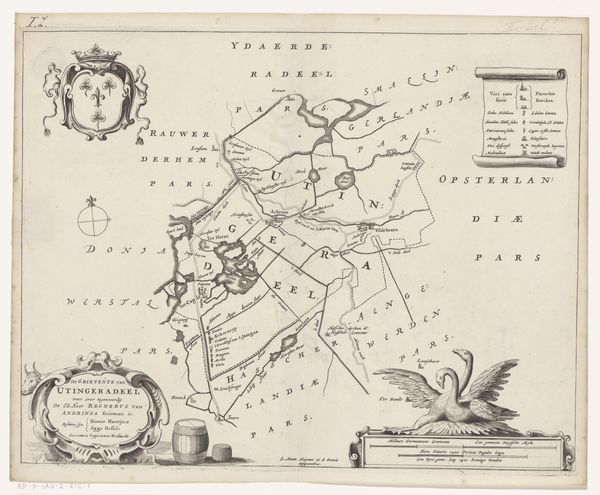
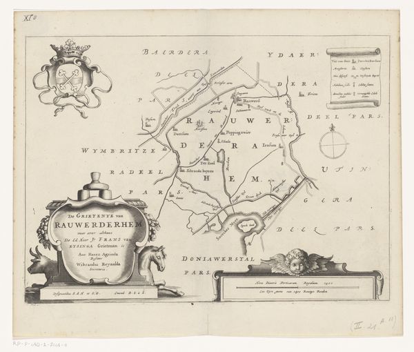
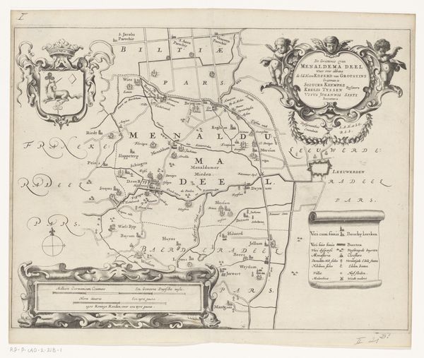
Curator: Here we have a remarkable map, titled "Kaart van de grietenij Doniawerstal," dating back to 1664. Jacob van Meurs is credited with this Dutch Golden Age piece currently held at the Rijksmuseum. It’s a detailed engraving, with ink and pen drawing. Editor: You know, looking at it, it feels almost… whimsical? It's all precise lines and careful labeling, but there’s a playfulness to the cherubs perched on the decorative elements. I imagine getting intentionally lost while referencing something like this. Curator: Indeed. Cartography at this time was less about absolute accuracy, and more a blend of science, artistry, and political statement. These maps were often commissioned by local governments, demonstrating not just the layout but also the region's prosperity and importance. Notice the coat of arms; it tells a silent story of the families and powers governing Doniawerstal. Editor: Absolutely, and those little details… almost like doodles amongst the official lines, give it so much character! What fascinates me is imaging someone, with only candlelight probably, meticulously crafting each line. It’s both technical and intensely human, don't you think? Almost contradictory somehow. Curator: Exactly. The contrast is palpable. This map serves not only as a geographical record, but also offers an insight into the societal and power structures prevalent at that period in the Netherlands. How land ownership and governance influenced the very representation of space. The map isn’t simply representing reality; it's constructing a certain reality. Editor: And perhaps that carefully constructed reality is also trying to hint that things were perfectly calm and controlled... when, in reality, life on that land probably had chaos and drama mixed in with everyday tranquility, no? I find this kind of "civilizing" spin so funny. Curator: That's a really astute point. It reflects how visual media often participated in shaping narratives that reinforced the status quo. A tension between reality and its controlled representation. Editor: I suppose, if nothing else, it does show you how some things never change, after all this time. Curator: Ultimately, this "Kaart van de grietenij Doniawerstal" takes us beyond mere location; it’s a visual window into a specific time and place in Dutch history. Editor: It's amazing how this old drawing opens up so many avenues of thinking. History and imagination, all tied up in ink and paper.
Comments
No comments
Be the first to comment and join the conversation on the ultimate creative platform.
More like this