About this artwork
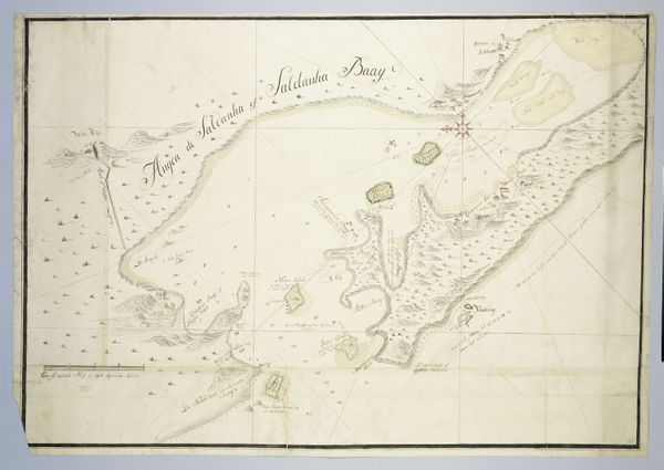
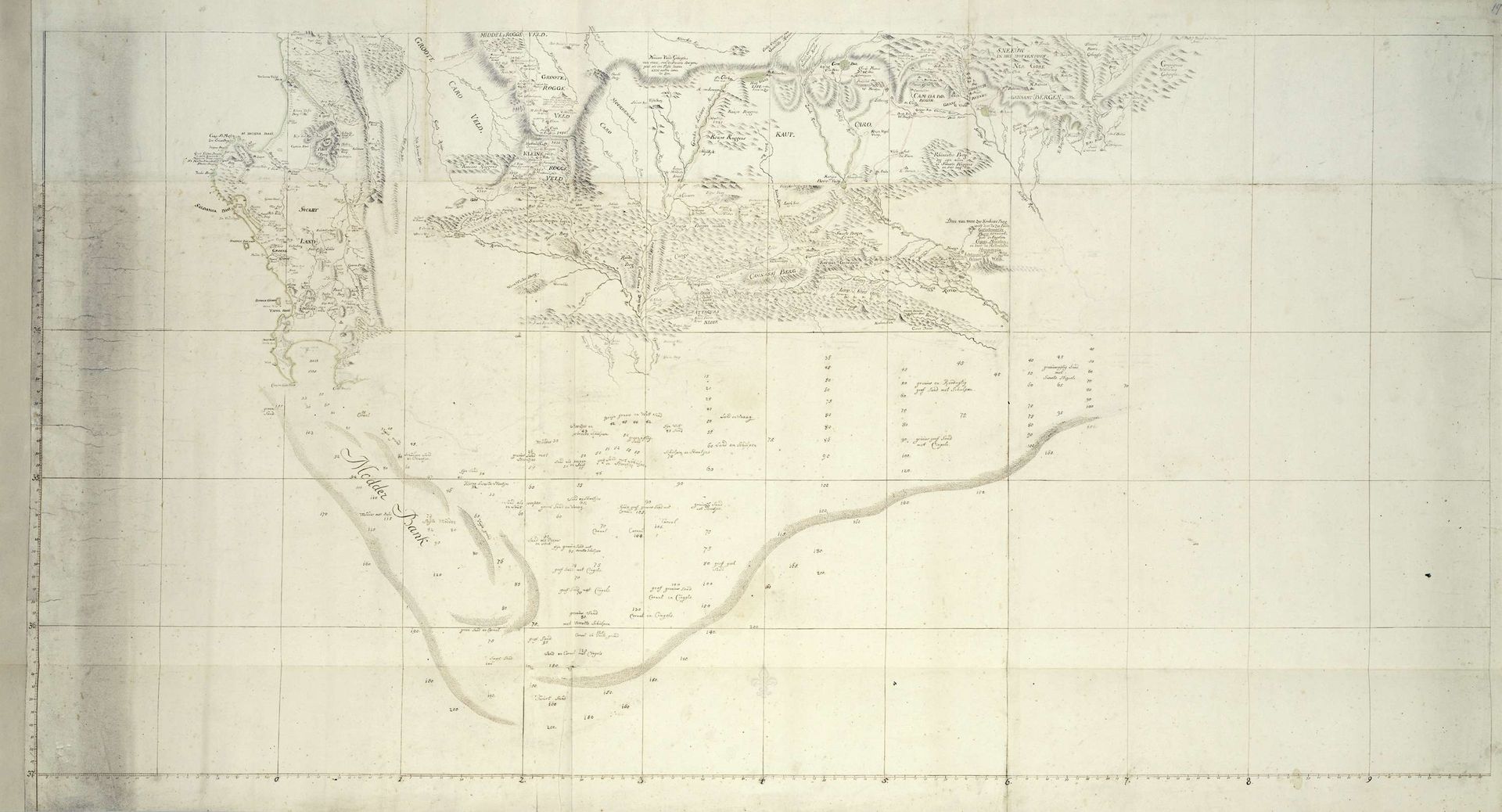
Curator: Immediately, I'm struck by the ghostliness of the work. The pale ink on paper creates a fragile and somewhat ethereal quality. Editor: Indeed. This is "Map of the Southern Part of South Africa" created after 1786 by Robert Jacob Gordon. It's a fascinating example of Neoclassical cartography using ink on paper. But it's more than just geography, it's a testament to the political landscape of the time. Curator: The structure of the map itself is interesting, almost incomplete. What stands out to you about the forms and spatial relations portrayed? Editor: What’s compelling here is Gordon's role as a military commander in the Dutch East India Company. This map reflects not just geographical exploration but colonial ambition, the act of naming and claiming territory. He is deciding who belongs and who does not. Curator: It certainly seems Gordon prioritizes strategic landmarks and waterways, essential for trade and control. His focus seems geared more towards resource extraction and movement of goods. I agree with you entirely that there are political forces shaping what information he deems fit to memorialize. Editor: His use of line—see the faint grid overlaid onto the region to establish precise spatial relationships—mirrors the Enlightenment’s emphasis on scientific rationalism. Also notice that even though this appears unfinished, the very act of sketching can be construed as an act of possession, right? Curator: Absolutely. And it speaks to the inherent power dynamics present in mapmaking during this era. Consider, who was this map intended for? Who had access to this knowledge and how was it used? Who was excluded? It opens up this interesting exploration of colonial legacy and its contemporary resonances. Editor: Yes. Analyzing Gordon’s visual choices invites questions about power, perspective, and representation. Curator: Precisely. The careful rendering highlights both a sense of observation and a strategic framing. These dual elements create a tension within the work, underscoring that knowledge itself can be a tool of colonization. Editor: I’ll be thinking about how these maps can reinforce existing power structures and to whom its creator thought would behold it.
Artwork details
- Medium
- drawing, print, paper, ink
- Dimensions
- , , height 750 mm, width 1480 mm
- Copyright
- Rijks Museum: Open Domain
Tags
Comments
Share your thoughts
About this artwork
Curator: Immediately, I'm struck by the ghostliness of the work. The pale ink on paper creates a fragile and somewhat ethereal quality. Editor: Indeed. This is "Map of the Southern Part of South Africa" created after 1786 by Robert Jacob Gordon. It's a fascinating example of Neoclassical cartography using ink on paper. But it's more than just geography, it's a testament to the political landscape of the time. Curator: The structure of the map itself is interesting, almost incomplete. What stands out to you about the forms and spatial relations portrayed? Editor: What’s compelling here is Gordon's role as a military commander in the Dutch East India Company. This map reflects not just geographical exploration but colonial ambition, the act of naming and claiming territory. He is deciding who belongs and who does not. Curator: It certainly seems Gordon prioritizes strategic landmarks and waterways, essential for trade and control. His focus seems geared more towards resource extraction and movement of goods. I agree with you entirely that there are political forces shaping what information he deems fit to memorialize. Editor: His use of line—see the faint grid overlaid onto the region to establish precise spatial relationships—mirrors the Enlightenment’s emphasis on scientific rationalism. Also notice that even though this appears unfinished, the very act of sketching can be construed as an act of possession, right? Curator: Absolutely. And it speaks to the inherent power dynamics present in mapmaking during this era. Consider, who was this map intended for? Who had access to this knowledge and how was it used? Who was excluded? It opens up this interesting exploration of colonial legacy and its contemporary resonances. Editor: Yes. Analyzing Gordon’s visual choices invites questions about power, perspective, and representation. Curator: Precisely. The careful rendering highlights both a sense of observation and a strategic framing. These dual elements create a tension within the work, underscoring that knowledge itself can be a tool of colonization. Editor: I’ll be thinking about how these maps can reinforce existing power structures and to whom its creator thought would behold it.
Comments
Share your thoughts