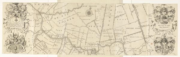
Kaart van de ambachten Drechterland en de Vier Noorder Koggen after 1736
0:00
0:00
hendrikdeleth
Rijksmuseum
print, engraving
#
dutch-golden-age
# print
#
landscape
#
geometric
#
engraving
Dimensions: height 954 mm, width 1224 mm
Copyright: Rijks Museum: Open Domain
Editor: So, this engraving is "Kaart van de ambachten Drechterland en de Vier Noorder Koggen," created after 1736 by Hendrik de Leth. It’s a map, and it feels very precise, but also… strangely beautiful? Almost like a Dutch Golden Age landscape painting in map form. What stands out to you when you look at this? Curator: Well, darling, it takes me back! To a time when maps weren't just about getting from point A to point B, but about portraying a sense of place. I see here the Dutch Golden Age obsession with both science and art merging seamlessly. You see the landscape lovingly, geometrically captured. Each little division promising a story of the folk who resided. Almost as if it whispers a tale of the land it oversees. Does it evoke something similar in you? Editor: Definitely! It makes me wonder about the people living in these little "cogges" or regions. Were they even aware their home was being documented with such detail and artistry? Curator: Ah, a marvelous question! Likely some were, especially those who commissioned such works. Remember, prints like these circulated, building a shared cultural imagination. This wasn’t just information; it was about pride, ownership, and defining identity. Almost like today's 'stories' shared by friends to see and engage with, right? What more can we learn about ourselves in looking at others? Editor: That’s a great way to put it. It’s like a really elaborate, historical humblebrag. I never thought of maps that way before! Curator: Precisely! And isn't that what art is all about? Reframing how we see the world, and then passing that new found joy of wonder to the next explorer. Editor: I guess you are right. This was really insightful, thank you!
Comments
No comments
Be the first to comment and join the conversation on the ultimate creative platform.
More like this