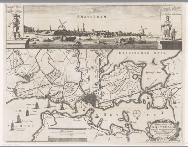
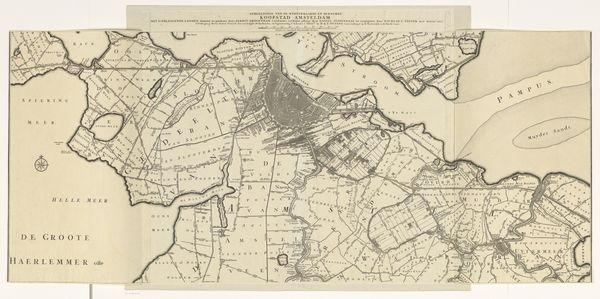
Profiel van Amsterdam met een kaart van de blokkade door de troepen van Willem II, 1650 1650 - 1654
0:00
0:00
pieternolpe
Rijksmuseum
print, etching
#
baroque
#
dutch-golden-age
# print
#
etching
#
landscape
#
cityscape
Dimensions: height 430 mm, width 522 mm
Copyright: Rijks Museum: Open Domain
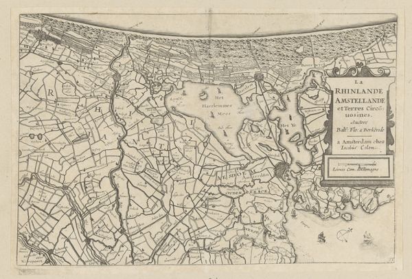
Curator: Welcome. We are standing before Pieter Nolpe's print, "Profiel van Amsterdam met een kaart van de blokkade door de troepen van Willem II, 1650," dating from 1650-1654, an etching held at the Rijksmuseum. Editor: It strikes me as a meticulously rendered landscape; the city rendered in a panorama above the schematics of cartography, quite sterile. The visual impact is quite sobering. Curator: Indeed. Observe how the print is structured. At the top, we have a panoramic view of Amsterdam itself, precise in its architectural details, followed below with a detailed map illustrating the blockade of the city. The choice of etching provides clear and sharp lines, necessary for both perspectival accuracy and cartographic detail. Editor: Yes, but beyond the technical prowess, there’s a narrative of power and control being presented. Consider the context. This work emerges from a volatile political moment; Amsterdam under pressure. Nolpe is visually articulating not just a city but a moment of political constraint, of power relations. The grid of the map imposes order, suppressing a far more complicated sociopolitical dynamic at play. Curator: The work certainly captures a tension. There's a precision to the rendering of the buildings, a commitment to depicting the urban space with fidelity, yet combined with an almost clinical representation of military positioning. The balance between artistry and utility, typical of the Dutch Golden Age, creates the intrigue. Editor: I read that artistry as being deliberately complicit. There’s no overt critique here, only documentation, yet in its meticulousness, the artist legitimizes, perhaps unintentionally, the very power structures he’s depicting. Curator: A provocative reading. I tend to read the neutrality of style as a more ambivalent artistic strategy that leaves room for nuanced interpretations. Perhaps Nolpe offers a platform to scrutinize, reflect and assess our political moment. Editor: Perhaps... That ambiguity might be its most enduring feature. Curator: Indeed. It provides a rich dialogue.
Comments
No comments
Be the first to comment and join the conversation on the ultimate creative platform.
More like this