About this artwork
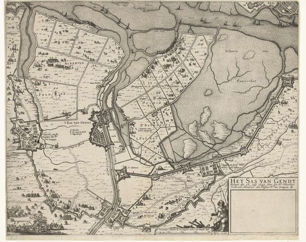
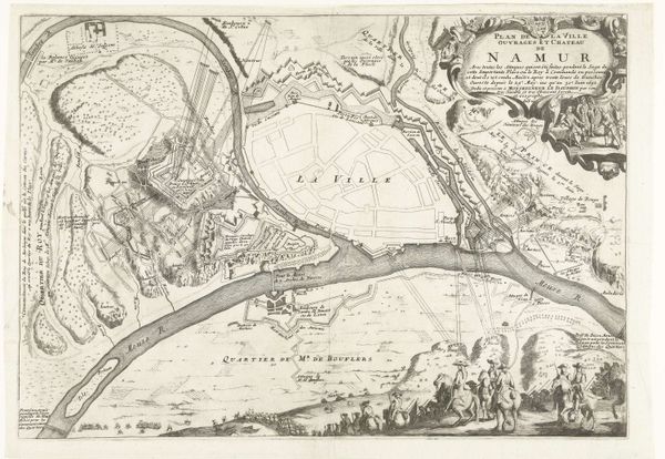
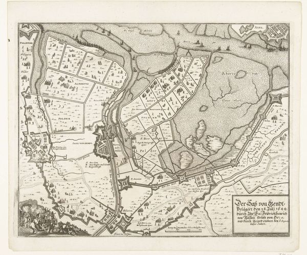
Curator: Here we have an etching from between 1649 and 1651, titled "Kaart van beleg en verovering van Sas-van-Gent, 1644" or "Map of the Siege and Conquest of Sas-van-Gent, 1644." It is currently held at the Rijksmuseum. Editor: It strikes me as an exercise in perspective more than a record of military action. The lines are incredibly precise, the detail almost overwhelming in places. There's a stark contrast between the chaos implied by the siege and the cool, ordered rendering of the landscape. Curator: Exactly. The anonymous artist used ink to create a seemingly objective overview of the siege and conquest, but maps were never neutral. Consider what a tool like this would have meant to military planners or those seeking to understand the geopolitical landscape of the time. Editor: You’re right, this isn’t simply topography; the artist employs linear perspective to build a symbolic space. The rendering feels almost geometric, which seems like a way to assert control over chaotic events. Each stroke becomes a claim, a definition. Curator: Yes, even the inclusion of minute details, the tiny figures engaged in battle, the rendering of the waterways, contribute to a comprehensive vision of power and knowledge. They underscore a sense of order imposed upon the realities of war and territorial control. Editor: Thinking of the linework, it is interesting that thin, precise marks map a space, a narrative of war, conquest, and control, that transforms nature into territory through rigid, artificial geometries. The emotional effect is curiously absent, filtered out by this focus on precision. Curator: Though it seems emotionally removed, its stark presentation of land and battle is heavy with the implication of loss. By presenting a clear image of conquest, the artist communicates a lot about Dutch military aspirations during that period. It serves as a symbol of strategic dominance and control. Editor: Well said. Analyzing the composition has been a valuable entry point. Seeing how form reflects purpose truly unlocks so much about the moment captured, in ink. Curator: I agree completely; thinking about how such detailed maps impact history has broadened my understanding. It becomes more than just an artistic composition, more like an embodiment of strategy and ambition.
Kaart van beleg en verovering van Sas-van-Gent, 1644
1649 - 1651
Anonymous
@anonymousLocation
RijksmuseumArtwork details
- Medium
- drawing, print, etching, ink
- Dimensions
- height 281 mm, width 368 mm
- Location
- Rijksmuseum
- Copyright
- Rijks Museum: Open Domain
Tags
Comments
Share your thoughts
About this artwork
Curator: Here we have an etching from between 1649 and 1651, titled "Kaart van beleg en verovering van Sas-van-Gent, 1644" or "Map of the Siege and Conquest of Sas-van-Gent, 1644." It is currently held at the Rijksmuseum. Editor: It strikes me as an exercise in perspective more than a record of military action. The lines are incredibly precise, the detail almost overwhelming in places. There's a stark contrast between the chaos implied by the siege and the cool, ordered rendering of the landscape. Curator: Exactly. The anonymous artist used ink to create a seemingly objective overview of the siege and conquest, but maps were never neutral. Consider what a tool like this would have meant to military planners or those seeking to understand the geopolitical landscape of the time. Editor: You’re right, this isn’t simply topography; the artist employs linear perspective to build a symbolic space. The rendering feels almost geometric, which seems like a way to assert control over chaotic events. Each stroke becomes a claim, a definition. Curator: Yes, even the inclusion of minute details, the tiny figures engaged in battle, the rendering of the waterways, contribute to a comprehensive vision of power and knowledge. They underscore a sense of order imposed upon the realities of war and territorial control. Editor: Thinking of the linework, it is interesting that thin, precise marks map a space, a narrative of war, conquest, and control, that transforms nature into territory through rigid, artificial geometries. The emotional effect is curiously absent, filtered out by this focus on precision. Curator: Though it seems emotionally removed, its stark presentation of land and battle is heavy with the implication of loss. By presenting a clear image of conquest, the artist communicates a lot about Dutch military aspirations during that period. It serves as a symbol of strategic dominance and control. Editor: Well said. Analyzing the composition has been a valuable entry point. Seeing how form reflects purpose truly unlocks so much about the moment captured, in ink. Curator: I agree completely; thinking about how such detailed maps impact history has broadened my understanding. It becomes more than just an artistic composition, more like an embodiment of strategy and ambition.
Comments
Share your thoughts