drawing, etching
#
drawing
#
dutch-golden-age
#
etching
#
landscape
#
river
#
etching
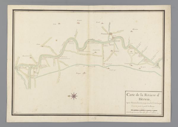
Dimensions: height 617 mm, width 400 mm
Copyright: Rijks Museum: Open Domain
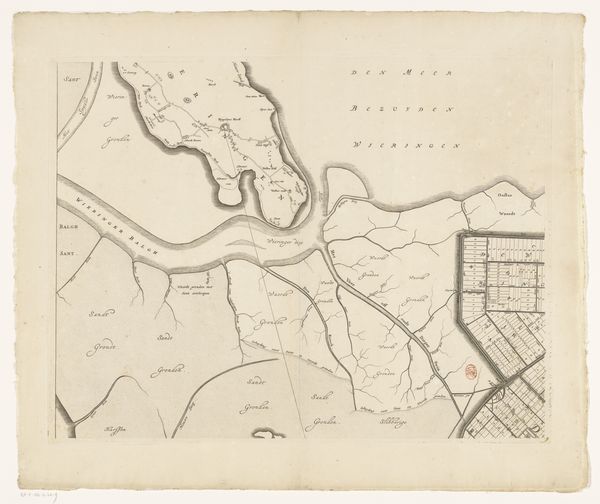
Curator: This etching, dating back to 1692, presents the third section of a map illustrating the River Eem, created by Thomas Doesburgh. Editor: The detail is striking. Even with just black lines on this light tan field, there's something so...calming about the landscape it describes. It almost feels meditative. Curator: It does reflect a Dutch Golden Age sensibility. But I see more than just calmness. Consider that maps, even those seemingly objective, are deeply embedded with power dynamics. Who commissioned this? What purpose did it serve? Editor: Well, the cartography is undoubtedly beautiful. Look at how the river snakes its way through the countryside. The trees, rendered so delicately... it speaks of humanity's relationship to nature and the symbolism inherent in navigating one's world. The compass rose suggests not just direction, but perhaps also fate, the winds of fortune... Curator: Precisely. But who got to chart that course? We can ask, how was the land divided, who controlled the waterways, and what did that mean for the people living there? These "objective" depictions are rarely neutral in their consequences, reflecting control and ownership in a given time. The small icons represent the population, the structures, but don’t invite us into their stories. Editor: The city's fortified layout, represented within, conveys a sense of security, safety, boundaries – literally and metaphorically, wouldn't you say? What is allowed in, kept out? It suggests that the civilization itself contains ideas about purity and separation that were valued. Curator: And that protection may have been for some at the expense of others, or for strategic goals, not civic virtue. How might the use of the river, so elegantly rendered, impact agriculture, trade, and perhaps, resource extraction that further reinforced inequalities? These visualizations are inseparable from complex political and economic webs. Editor: A reminder that symbols are always part of a larger network of meanings. And, perhaps, how easily a simple map conceals whole worlds, cultures, stories! Curator: It's a potent reminder that even seemingly straightforward representations encode deeply ingrained social and political values. Approaching the map through that lens encourages questioning the status quo it visually normalizes.
Comments
No comments
Be the first to comment and join the conversation on the ultimate creative platform.
More like this