drawing, print, paper, engraving
#
drawing
#
baroque
# print
#
landscape
#
paper
#
history-painting
#
engraving
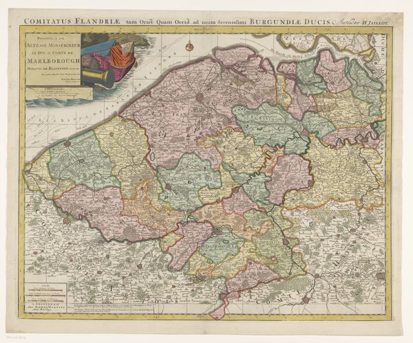
Dimensions: height 503 mm, width 618 mm
Copyright: Rijks Museum: Open Domain
Editor: So, this is an engraving on paper, titled "Kaart van het graafschap Vlaanderen," or "Map of the County of Flanders," created anonymously in 1694. It’s incredibly detailed! How would you interpret this work, looking at it as a cultural artifact? Curator: I see this not just as a geographical record, but as a potent assertion of power. Maps in the Baroque period, especially those as ornate as this, served to define territories, legitimize rule, and project influence. Consider the detailed rendering of towns and landscapes. What do you think that conveys to the viewer, especially someone in a position of power? Editor: Well, it makes Flanders look very civilized, very… controllable, almost like a garden carefully laid out. Is it maybe communicating the idea of ownership or dominance? Curator: Precisely! The meticulousness suggests a deep understanding, even mastery, of the land. And consider who this map was made for: the Duke of Burgundy. It's a statement about his claim to that territory and a demonstration of knowledge which supports his power. Notice, too, how the ornamental details, like the crests, reinforce the visual language of authority. What about the style of landscape representation do you find most interesting? Editor: I'm fascinated by the attempt to depict three dimensions on a flat surface. It’s not photorealistic, but it aims to give a sense of the actual land. It makes me think about how representations of space impact how people understand the space itself. Curator: Exactly! These maps literally shaped perceptions of territory and therefore shaped politics and administration, the organization of society, even people's daily experience of their homeland. We have to remember these weren't neutral documents; they actively participated in constructing a sense of place and power. Editor: It’s interesting to think of a map as an act of political theater as much as a practical tool. I'll never look at a map the same way again! Curator: And I'm reminded of how critical it is to investigate the context in which cartography and other visual productions take place, the world which the artist engages.
Comments
No comments
Be the first to comment and join the conversation on the ultimate creative platform.
More like this