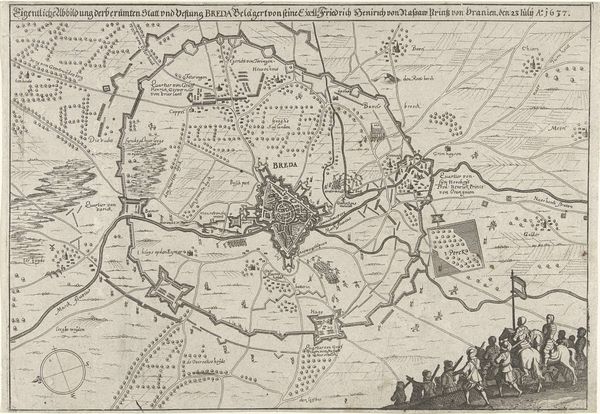
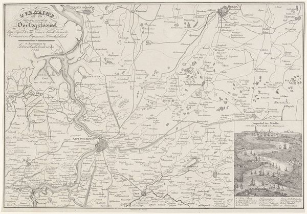
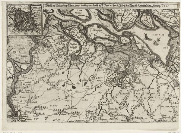
Kaart met de tocht van Maurits door Brabant, 1602 1608 - 1610
0:00
0:00
florisbalthasarszvanberckenrode
Rijksmuseum
drawing, print, ink, engraving
#
pen and ink
#
drawing
#
pen drawing
#
dutch-golden-age
# print
#
pen illustration
#
pen sketch
#
old engraving style
#
ink
#
geometric
#
engraving
Dimensions: height 202 mm, width 318 mm
Copyright: Rijks Museum: Open Domain
Curator: What strikes me first is the overwhelming detail of this cartographic print, “Kaart met de tocht van Maurits door Brabant, 1602,” made sometime between 1608 and 1610. It feels incredibly precise and structured. Editor: My initial reaction goes in a different direction; it seems less like a precise map and more like a manufactured narrative. Maps were strategic documents used to consolidate and project power, and that context immediately frames how I understand it. Who created it and why? Curator: Floris Balthasarsz van Berckenrode made it as an engraving, using pen and ink. Its lines are so crisp, delineating borders and landmarks. I am intrigued by the almost decorative quality of the land divisions, a tension between practicality and aesthetic choices. The contrasting light and dark areas make me feel disoriented as the varying sizes of letters emphasize a compositional balance instead of readability. Editor: Yes, look closer. I see not just geographical representation, but the labor behind creating this representation, the economy of printmaking during the Dutch Golden Age, the networks involved in its distribution. I want to understand its use— who was consuming these maps and how did it inform their understanding of geopolitical power dynamics? I also wonder, who benefits most from the creation of these printed maps that further cemented borders in the landscape? Curator: Your analysis grounds this artwork within specific economic and historical currents, but what about its visual language and historical impact? Don't you think the engraver used visual tropes strategically to promote the Dutch Republic during that period? The embellishments give authority to this overview. Editor: The visual style contributes to a broader narrative. These were created to sway public sentiment to project and expand Dutch interests during times of intense political instability, while establishing their domination of crucial waterways, a visual tool, ultimately. How does it contribute to colonial practices through mapping unknown territories? Curator: It's amazing to see how a seemingly straightforward map can hold so many layers. Looking through your lens gives an impactful way to grasp the convergence of design and industry in establishing the Republic’s identity during that era. Editor: Exactly, and decoding how printed maps contribute to constructing power relationships really enhances one's experience.
Comments
No comments
Be the first to comment and join the conversation on the ultimate creative platform.
More like this