graphic-art, print, ink, engraving
#
graphic-art
#
medieval
# print
#
pen illustration
#
landscape
#
ink line art
#
ink
#
cityscape
#
engraving
Dimensions: height 376 mm, width 489 mm
Copyright: Rijks Museum: Open Domain
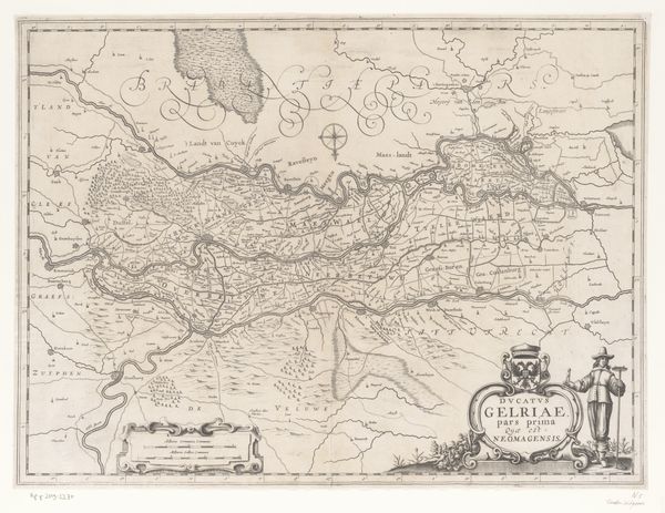
Editor: This is an old map, "Kaart van het graafschap Zutphen," made sometime between 1617 and 1648 by an anonymous artist. It’s an engraving, so black ink on paper. I'm struck by how detailed it is and I wonder how accurate it was at the time. What can you tell me about what's depicted here? Curator: Accuracy is interesting; these maps weren’t always about literal geographical precision. Look closer—do you notice anything about how power might be represented here, not just geography? Editor: I see small illustrations of buildings or towns that maybe signify something important? Curator: Exactly! This map presents not just space but also a worldview, prioritizing certain settlements and territories. Consider Zutphen's location. What can it tell you about Dutch identity in a period marked by the Eighty Years' War and nascent nationalism? Editor: So it's a projection of political power through the guise of a simple map. Curator: Yes. And look at the landscape itself, the carefully rendered forests and rivers. Who benefits from these representations of the region’s natural resources? Editor: Maybe wealthy landowners, those controlling trade routes...It gives the sense of surveying a space that can be owned, exploited. Curator: Precisely. How does knowing this affect your reading of the artwork now? Editor: I see it less as an innocent depiction and more as an assertion of dominance, creating a visual order reflecting the priorities of a specific class and political power. Curator: Exactly. Now we might think about the agency of the artist, the choices made. Each line holds intention. Editor: I guess I see that this map contains multiple layers: geographical, artistic, political, even socioeconomic! Curator: Indeed. Now you are truly seeing the map.
Comments
No comments
Be the first to comment and join the conversation on the ultimate creative platform.
More like this