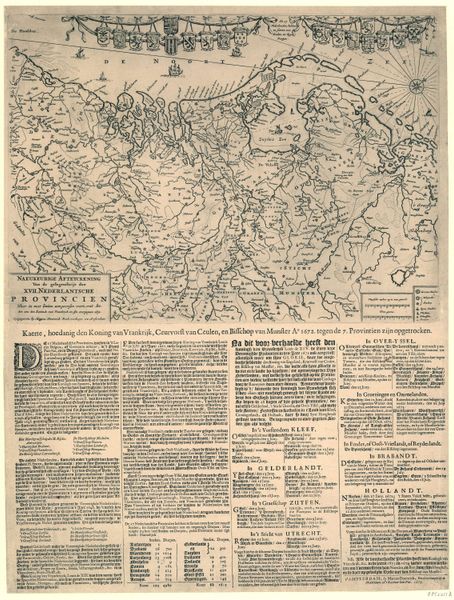
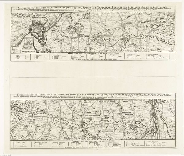
Kaart van de Nederlanden waarop is aangegeven tot waar de vijandelijke troepen in de jaren 1672-73 zijn opgerukt 1673
0:00
0:00
anonymous
Rijksmuseum
print, engraving
#
baroque
# print
#
history-painting
#
engraving
Dimensions: height 690 mm, width 553 mm
Copyright: Rijks Museum: Open Domain
Curator: This baroque-style print from 1673 is titled "Kaart van de Nederlanden waarop is aangegeven tot waar de vijandelijke troepen in de jaren 1672-73 zijn opgerukt" which translates roughly to "Map of the Netherlands indicating where the enemy troops advanced in the years 1672-73." Editor: It’s an intriguing composition. There is something inherently disturbing about maps illustrating invasion. The meticulous lines, the delicate script detailing the places overrun, almost amplify the sense of violation suffered. Curator: Absolutely. Observe how the engraving emphasizes certain territories with denser line work, almost like visual echoes of occupation. Consider also the placement of the elaborate cartouche featuring allegorical figures that adds a layer of political commentary on this war, commonly called the Disaster Year of 1672-73. Editor: Yes, and you can feel the weight of production. This isn’t just lines on paper; it represents countless hours of skilled labor. Think about the materials too - the ink, the paper, sourced and crafted. Even the paper's very survival speaks to enduring properties that surpass this war itself. The detailed rendering of terrain contrasts with its use as propaganda and political statement—the artist highlighting details and data points but creating something that speaks about a specific time. Curator: Precisely. It is difficult not to read a piece such as this using semiotics. It attempts to encode concepts like threat, dominion, and resilience via geographic representation. The engraver's technique, too, has clear connotations, echoing the meticulousness desired in that age and linking directly to broader power systems that governed this production and its dissemination. Editor: I see the tension here. It’s this dialogue between the hand of the maker and its representation and implications. Even though created centuries ago, looking at these types of prints encourages thoughts about how we document, understand, and then historicize conflict today via material means and distributed knowledge. Curator: Indeed, analyzing these works, especially this one, is essential for any deep study of baroque sensibilities. I feel like this image provides so much insight. Editor: And to me, this engraving resonates even now. I'm stuck thinking about what gets captured when rendering historical cartographies during conflict, especially by hand with so much care—quite the human feat and reflection.
Comments
No comments
Be the first to comment and join the conversation on the ultimate creative platform.
More like this