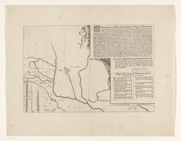
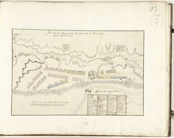
Legerkampen van de Hollandse en de Franse legers bij Leuven, ca. 1705 1705
0:00
0:00
drawing, watercolor, ink
#
drawing
#
baroque
#
landscape
#
watercolor
#
ink
#
watercolor
Dimensions: height 158 mm, width 200 mm
Copyright: Rijks Museum: Open Domain
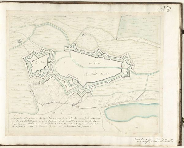
Curator: Here we have "Legerkampen van de Hollandse en de Franse legers bij Leuven, ca. 1705," which translates to "Military Camps of the Dutch and French Armies near Leuven, around 1705," rendered with ink and watercolor by Samuel Du Ry de Champdoré. It dates, of course, to about 1705. What are your first thoughts? Editor: It strikes me as delicate for a map of war, almost ornamental with its fine lines and subtle washes. The scale is particularly interesting, a miniature theater of conflict. Curator: It’s an artifact from a period of intense geopolitical rivalry. This map likely served not just a strategic function, but also a propagandistic one, shaping perceptions of power. The placement of these camps speaks volumes. Editor: Precisely, beyond the topographic representation, notice how the camps themselves are depicted. They are more like formalized emblems of power, with little flags atop that serve as both place markers, but also reinforce the emotional context for whom these wars would be impacting. The rendering feels so ordered, reflecting perhaps an idealized view of military engagement of the period. Curator: Interesting take! Also consider the very act of mapping – a symbolic claiming of territory, both physically and intellectually. This artwork performs that function very literally; creating order on a page reflecting, or maybe projecting it, onto the battlefield. The style feels connected to the broader Baroque sensibilities of the time, albeit applied to cartography rather than, say, portraiture or grand historical scenes. Editor: Definitely a tension there – this piece has the hallmarks of what was happening in landscape art during the time, yet with more of a utilitarian bent. It gives pause to how similar symbolism can both incite or quell emotion based on presentation. The washes soften the violent content just slightly. The symbolic flags flutter, suggesting both possession, and simultaneously impermanence. Curator: Right. We see this dance often with images of war. There's this compulsion to monumentalize battles to bolster national identity but simultaneously it runs headlong into the realities on the ground. The artist must walk a line carefully to portray power, without confronting or even reveling in the disturbing details. It makes it so the intended purpose and cultural significance often clashes when viewed by a modern audience. Editor: In that push and pull, a curious picture emerges: war presented with an unsettling aesthetic grace. It's a fascinating look at how even conflict can be rendered as a study in design and spatial relationships. Curator: A visual paradox indeed – war, mediated through the sensibilities of Baroque aesthetics and rendered into an intriguing and ultimately rather telling artifact of its time.
Comments
No comments
Be the first to comment and join the conversation on the ultimate creative platform.
More like this