print, ink, engraving
#
pen and ink
#
dutch-golden-age
# print
#
old engraving style
#
landscape
#
ink
#
ink colored
#
pen work
#
engraving
Dimensions: height 247 mm, width 340 mm
Copyright: Rijks Museum: Open Domain
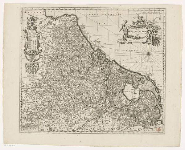
Curator: We're looking at Nicolaes van Geelkercken’s "Kaart van de Veluwe," an engraving likely made with pen and ink between 1653 and 1654, now residing here at the Rijksmuseum. Editor: It’s immediately striking how intricate this map is. The sheer density of detail, the almost obsessive rendering of every tree, every little waterway, it speaks to a tremendous amount of labor. Curator: Absolutely. Think about the skill and the time involved in engraving those fine lines onto the printing plate. You also see how the human element interacts with this landscape. Each carefully placed tree could tell a story about forestry practices of the time, and the presence of each house represents someone's home and, more broadly, society. Editor: And these locations are represented by tiny architectural symbols. Houses mean community, churches denote spiritual life, and mills represent technology driving the economy. Each village could be a small kingdom, defined by these symbolic shorthands. Note how those symbols are clustered near waterways – these become lifelines connecting settlements. Curator: Yes, water would've been a major mode of transportation, shaping social and commercial networks across the area. Analyzing these connections teaches us about systems of exchange and interaction. Editor: I also see the tension between the cultivated and the wild. Open spaces are interspersed among forests and small communities of houses. These patterns and divisions probably served as important landmarks. It speaks to how people organized space. Curator: This landscape, even depicted as a map, embodies power dynamics. Each plotted location indicates something or someone valuable enough to be represented and worth investing labor in mapping it out so precisely. And you notice the frame. That’s no objective boundary – it's there to create a unified view to exert a controlling narrative. Editor: Indeed. Maps always tell a story. It prompts me to reflect on our own relationships to place, power, and production in a different historical setting. Curator: I find the interplay between practical documentation and symbolic representation quite amazing. So much is captured beyond topography here, it offers a cultural imprint.
Comments
No comments
Be the first to comment and join the conversation on the ultimate creative platform.
More like this