drawing, ink, engraving
#
pen and ink
#
architectural sketch
#
drawing
#
old engraving style
#
landscape
#
ink
#
pen work
#
engraving
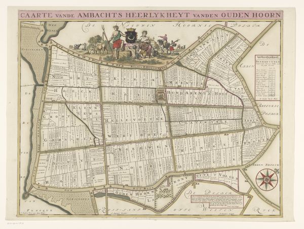
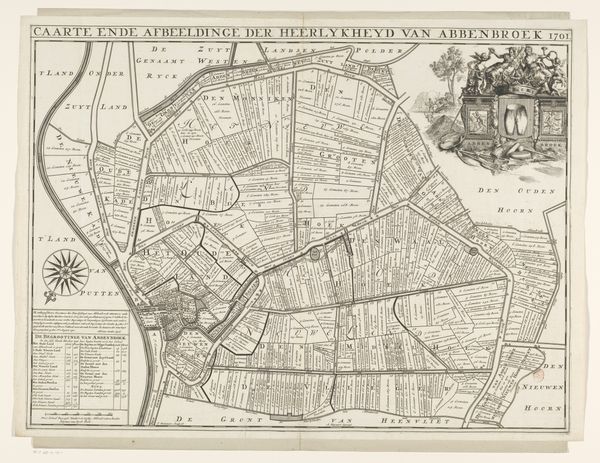
Dimensions: height 508 mm, width 650 mm
Copyright: Rijks Museum: Open Domain
Editor: Here we have “Kaart van de ambachtsheerlijkheid Oudenhoorn,” a drawing and engraving in ink by Jan Stemmers, from 1701. It's incredibly detailed. What I find striking is how the land seems both ordered and organic, rigid fields contrasting with natural coastlines. How do you interpret this work? Curator: Indeed, it's a fascinating glimpse into a very particular time and place. Notice how the map isn't just a record of geography, but also a potent symbol of ownership and control. The figures at the top, the crowned figures and perhaps merchants with livestock, stand as almost mythic guardians. They represent the authority and wealth associated with this “heerlijkheid”, this domain. Editor: So, it’s not just a map but a statement? Curator: Precisely. Consider the compass rose, almost an ornamental flourish in the corner. It guides not just physically, but perhaps morally, suggesting a proper direction for the land and its people. The neatly ordered fields, so carefully delineated, speak to a desire for dominion over nature. A cultural need made manifest through symbolism and careful rendering. Editor: The text feels very deliberate, too. Even the lettering seems symbolic. Curator: Absolutely. Calligraphy itself carries weight. It’s carefully chosen to reflect the solemnity and importance of the document, lending authority. Even the title is a proclamation. Editor: So, understanding this piece involves understanding the symbols that visually build power? Curator: Exactly. Think of maps as ideological statements disguised as practical tools. They encode beliefs about the world and our place within it. The symbolism here—rulers, compasses, and calculated plots—reveals a deeply ingrained cultural desire for order and possession. What do you make of that in relation to our contemporary understanding of land usage? Editor: It makes me consider how even seemingly neutral documents carry so much hidden cultural messaging. Thanks for sharing that insightful perspective. Curator: My pleasure. It’s a reminder that images speak volumes, often beyond their intended purpose, rippling through time.
Comments
No comments
Be the first to comment and join the conversation on the ultimate creative platform.
More like this